Principal Investigator – Martin Gold
Co-Principal Investigator – Martha Kohen
Project Coordinator – Jerry Murphy
Project Team
A team of international students and visiting scholars from the University of Florida School of Architecture under the direction of faculty and in collaboration with students from the Department of Urban and Regional Planning, external reviewers, and planning staff from the Town of Longboat Key combined efforts as the Urban Design Studio project team. Faculty and consultants engaged in advanced research and discussions with town planners to set up the primary work of the studio during the Spring of 2015. Selected students from the studio worked with collaborators and faculty to prepare the results of the studio in the form of this text and a media executive summary presentation.
Project Objective
Under the leadership of Mayor Jim Brown, the Longboat Key town commissioners, Dave Bullock, Alaina Ray, and many the other Longboat Key staff, this effort is one of many positive steps toward advancing a consensus vision for Longboat Key – ReCharting Longboat Key and creating new land development regulations to implement the vision.
The work presented in this book includes the research, analysis, findings, and integrated design proposals developed in the Urban Design Studio – a group of faculty, consultants, and students from the University of Florida School of Architecture. The Urban Design Studio project team is working in parallel with town staff and planners from the Florida Resilient Communities Initiative (FRCI) collaboratively to remedy (near term) conflicts and re-write (primary objective) the Longboat Key land development regulations. The goal of this parallel approach is to resolve elements causing properties to be non-conforming; to reveal a consensus vision that can set the priorities for the land development code, and then initiate a rewriting of the code toward implementation of the consensus vision.
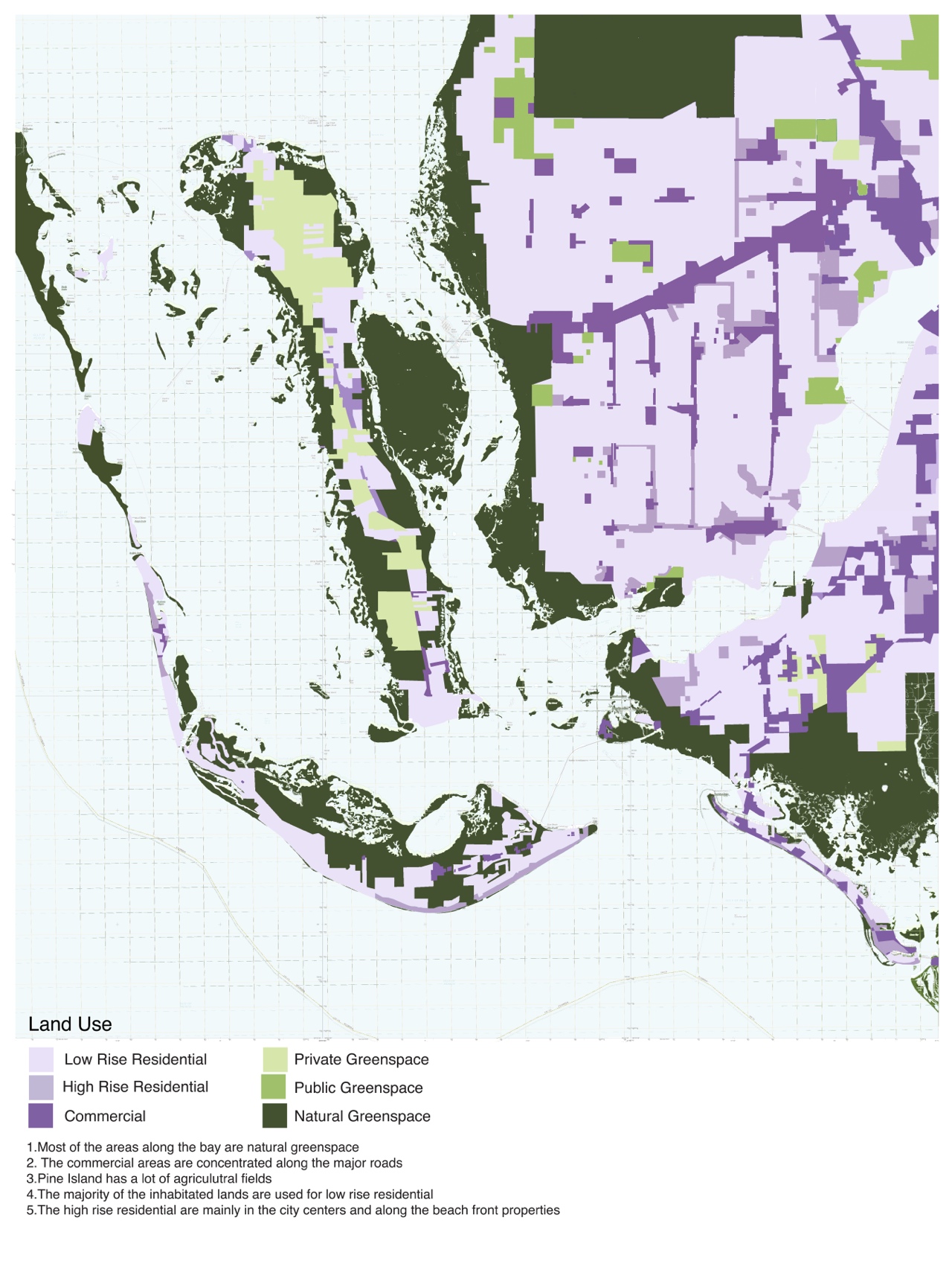
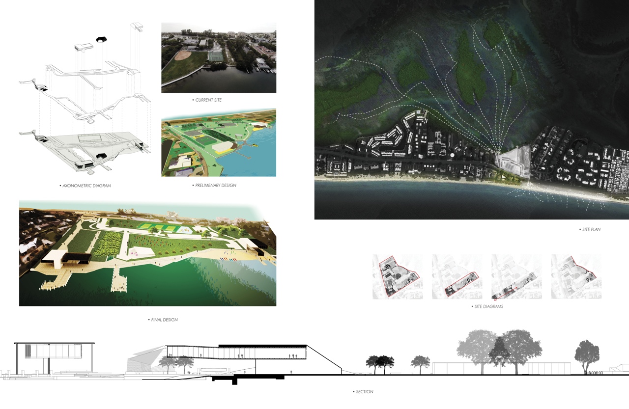
The Urban Design Studio has studied the prevalent opportunities and difficulties arising out of the geographic context, economic forces, resource availability, historic development, natural ecology, existing land uses, and projections of demographic trends, sea-level rise, shore erosion, and population trends.
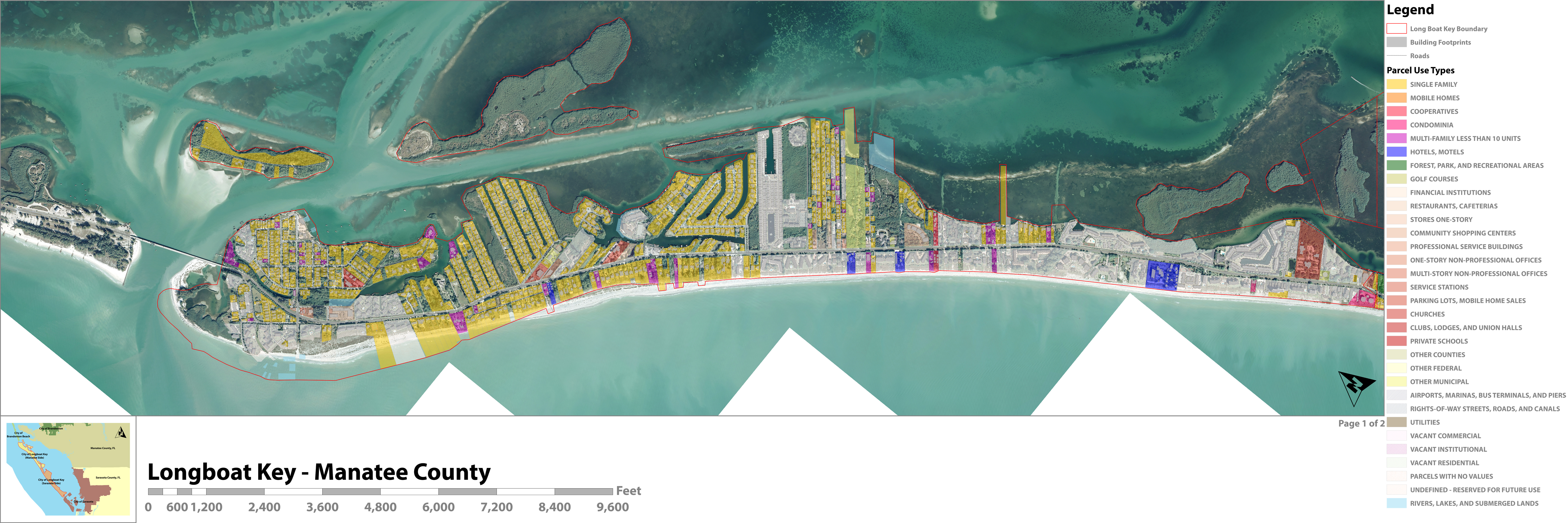
This information was utilized to develop master plan priorities and to identify and qualify thirteen ‘Locations of Opportunity’ on the Key that might be substantially reconsidered in the new land development regulations. The master plan priorities include understanding the linear nature of the key – 10 miles long and 0.42 miles wide (average) – as a collection of aligned places, nodes, or events forming more of a polycentric necklace structure than that of a more traditional town center with land in all (inland development) or at least three directions (coastal development). Although these ‘places’ are not presently emphasized along Gulf of Mexico Drive, they do exist and present a wide variety of semi-urban forms that could be enhanced to the benefit of the larger community.
Diagnostic Elements
Longboat Key is an inhabited barrier island on the West Coast of Central Florida, in need of future strategies toward resiliency and growth. It is a long and narrow island, 10 miles long with a width varying between 1,000 and 5,000 feet along the island’s course. It is bordered on the west side by the Gulf of Mexico seaboard – pristine quality waters overlooking unobstructed views of the sunset with white sand beaches and sea oat dunes.
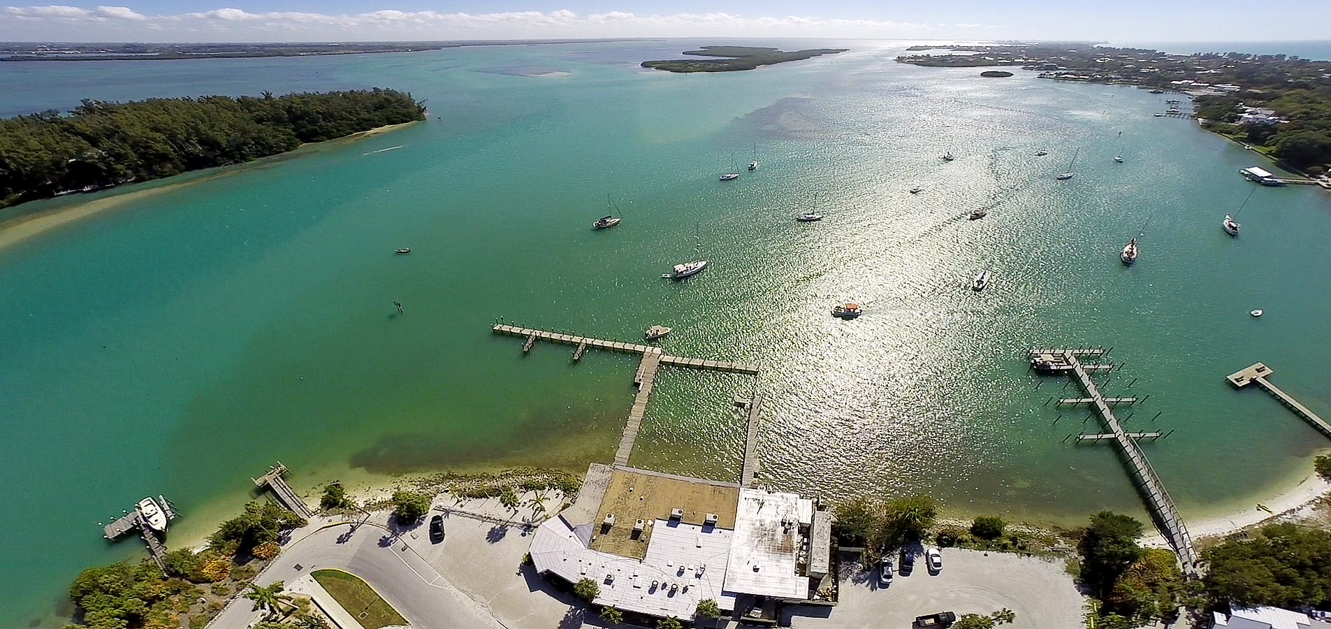
On the East side it faces Sarasota Bay; a body of clean water that is completely refreshed every two days through the tides that communicate between the bay and the sea through the North and South passes. The western areas of the island face the bay in an intricate pattern of tidal ecologies and have been substantially altered by amphibious developments. The island has interesting preserved ecological zones on the Northern and Southern tips, mangrove islands along with the central-eastern areas, interspersed with tidal marsh areas. Two public parks with native vegetation allow access to bay views. The Key’s residents circulate internally through a central highway – Gulf of Mexico Drive – leading to neighboring islands and bridging Sarasota Bay to reach the mainland.
Locations of Opportunity
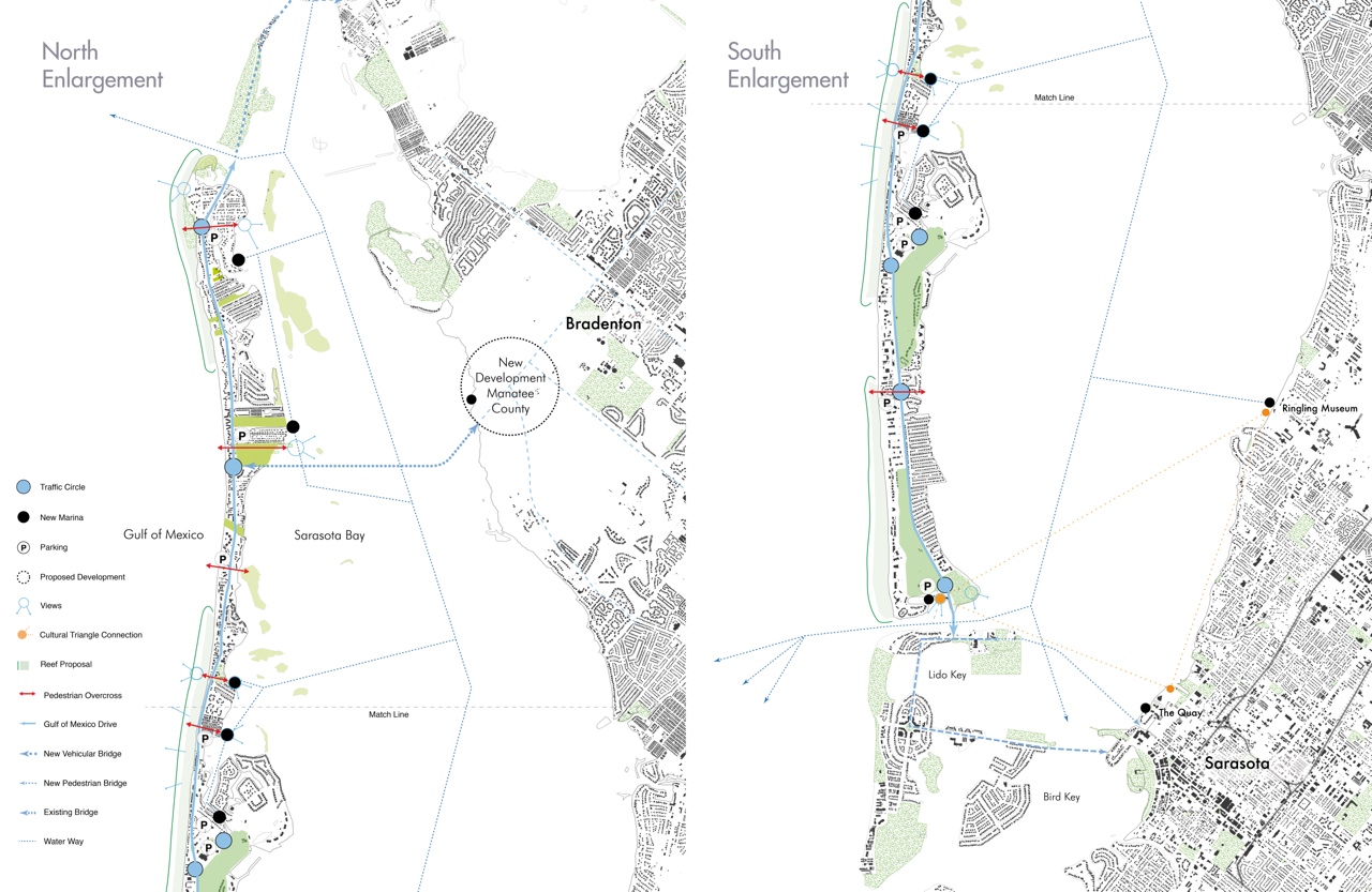
Gulf of Mexico Drive is also State Route 789 traversing the full length of Longboat Key, giving access through Anna Maria Island to the Manatee County mainland and South to US 41 through Lido Key, St Armands Key, and then bridging to the mainland at the downtown of the City of Sarasota. GMD is the main island thoroughfare, connecting the residential, commercial, and beach access points, public venues, downtown, emergency services, and utilities. It has a 100 feet right of way (ROW). Each of the 16 students chose from one of the sites chosen below:
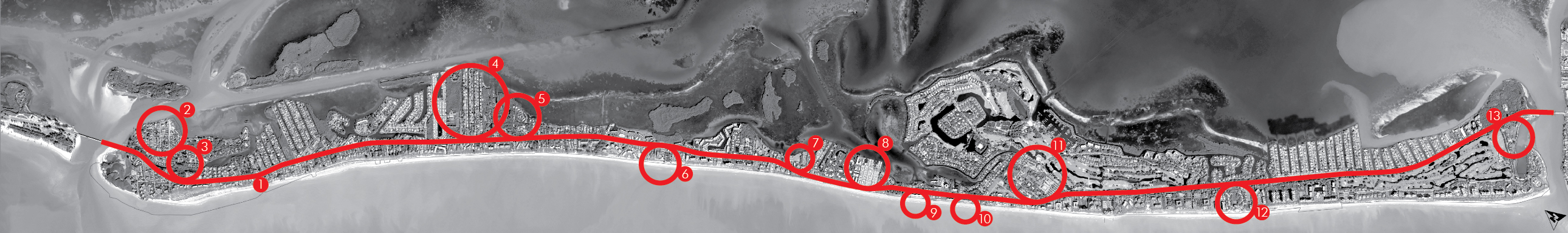
1) Gulf of Mexico Drive 2) Longbeach Village 3) Whitney Plaza and Ringling Fine Arts Center 4) Harry’s and St. Jude Street
5) Centre Shops and Durante Park 6) Hilton Hotel Site 7) Bayfront Park 11) Town Center 12) The Colony 13) South Key Threshold
Student Proposals:
Integrated Student Project Proposals
Students from the UF School of Architecture’s Master of Architecture program participated in the Longboat Key Urban Design Studio. Students participated in field research, met with staff and stakeholders, conducted precedent and archival research, and made both team and individual planning and design proposals for Longboat Key. Specific ‘Locations of Opportunity’, identified earlier in this report, were selected for detailed study and the development of schematic design proposals. Student proposals integrate master plan strategies, community interests, market forces, ecology, and strategies identified through location observations and responses. A range of project types – appropriate to the varied sites – were derived as part of an integrative process that brings together convergent and divergent priorities into a synthetic conceptual project proposal – integrated design.
Earlier in this report, development opportunities and recommended priorities were presented in coordination with master plan alternatives that present different priorities for optimization. For example, ecology might be favored over market demands or mobility might be optimized rather than new development to test the impacts of the preferences while considering other elements. In all cases, the range of community requirements – a healthy environment, infrastructure, resiliency, commerce… – are well-considered and balanced. Prioritization of community fabric is a difficult issue to bring to general consensus within any community and particularly when the language of codes and regulations is used as the basis for citizens and leaders to measure alternatives. The Urban Land Institute Advisory Panel clearly identified the obsolescence of the current 1980s code and its role in reinforcing a pattern of community infighting.
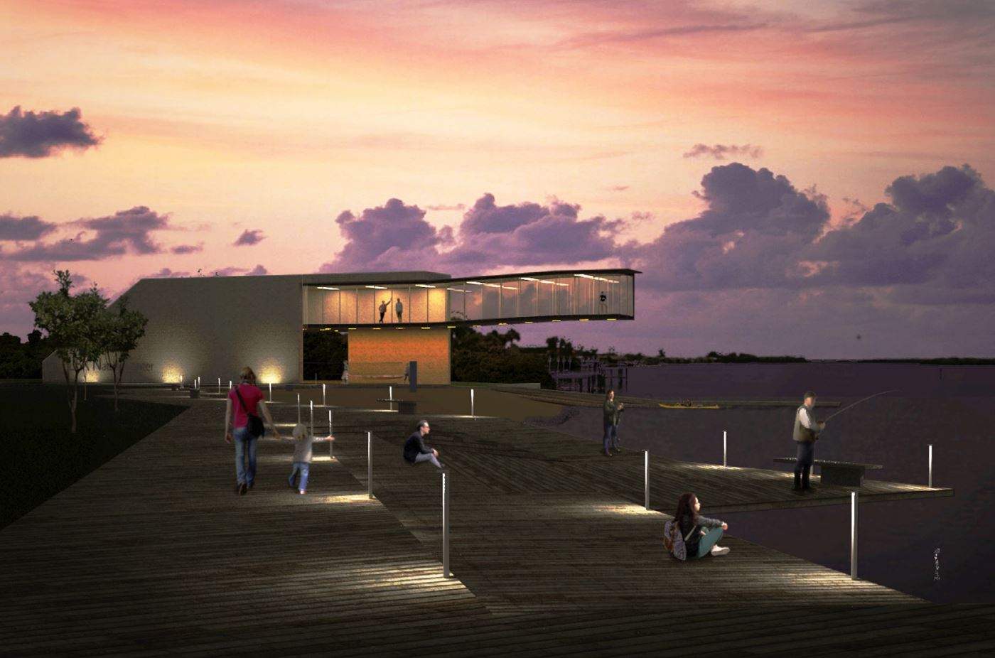
Longbeach and Bayside
Broad Street acts as a civic way between Gulf of Mexico Drive and bayside restaurants, deep-water mooring, and associated existing public dock/ramp infrastructure. Longbeach has notable historic platting with a viable grid network of streets and alleys. There currently exists a grass-roots culture of extended duration mooring in the unique deep-water cove.
Students have responded by striving to enhance the character of Broad Street as a gateway/ connector to the Gulf of Mexico for pedestrians and cyclists. Increased housing density as single-family residential on smaller lots. Exploring alley and grid structure and mixed demographic housing (in family or family managed second units) – doubling the number of units per site. This could take the form of garage apartments or bungalows with alley access.

Amphi-Bio City – Jesse Mantohac
Foreseeing Longterm Development in the Historic Fabric
Resiliency Through Floating – Silvia Aloisio
Permanence of Historic Grid
Amphi-Bio City – Jesse Mantohac
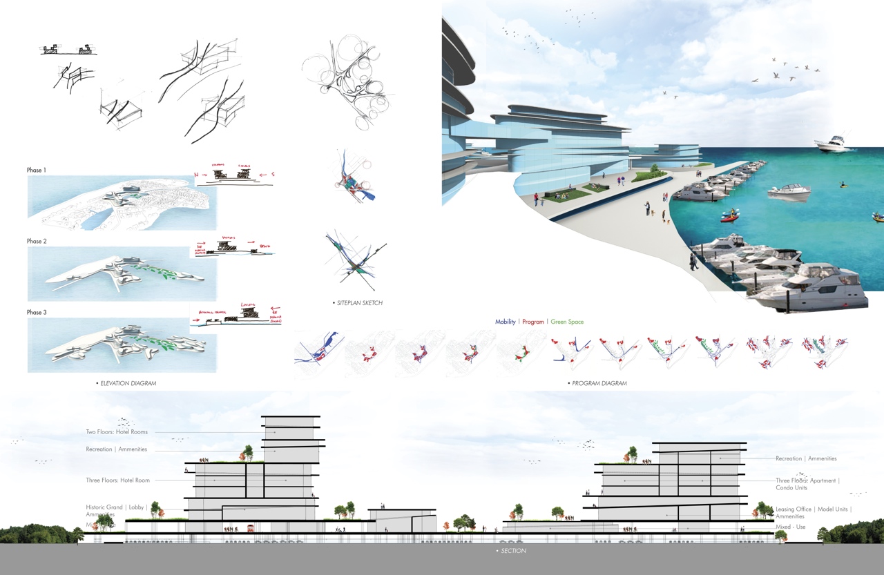
The project is undertaken in three phases, with consideration of three and five-foot sea level rise predictions. Considering the programmatic ideas that stakeholders listed, this project selects the introduction of a mixed-use community, kayak launch pad, the fishing marina at Longbeach, expanded beach access, art district, recreation facility, and residences.
Phase one proposes a new infrastructure with a mixed-use community. A bridge will link the Gulf of Mexico Drive to Jackson Way leading to the art center; the second level of elevated public spaces is introduced at Whitney Plaza for pedestrian, biking, and bus service, (leaving the ground level for parking, moving people vertically).
The hotel is located in the northern part which leads the visitors to the welcome and historic centers from the north access. The apartments and condos are located in the southern part of the area; a relocation proposal for the rest of the housing on the island is affected by environmental resiliency issues. The first level remains allocated for mixed-use spaces. Phases two and three consider the five-foot sea level rise prediction which puts the selected site underwater. The project is called amphibious because of its permanence and adaptability under the changing sea-level conditions.
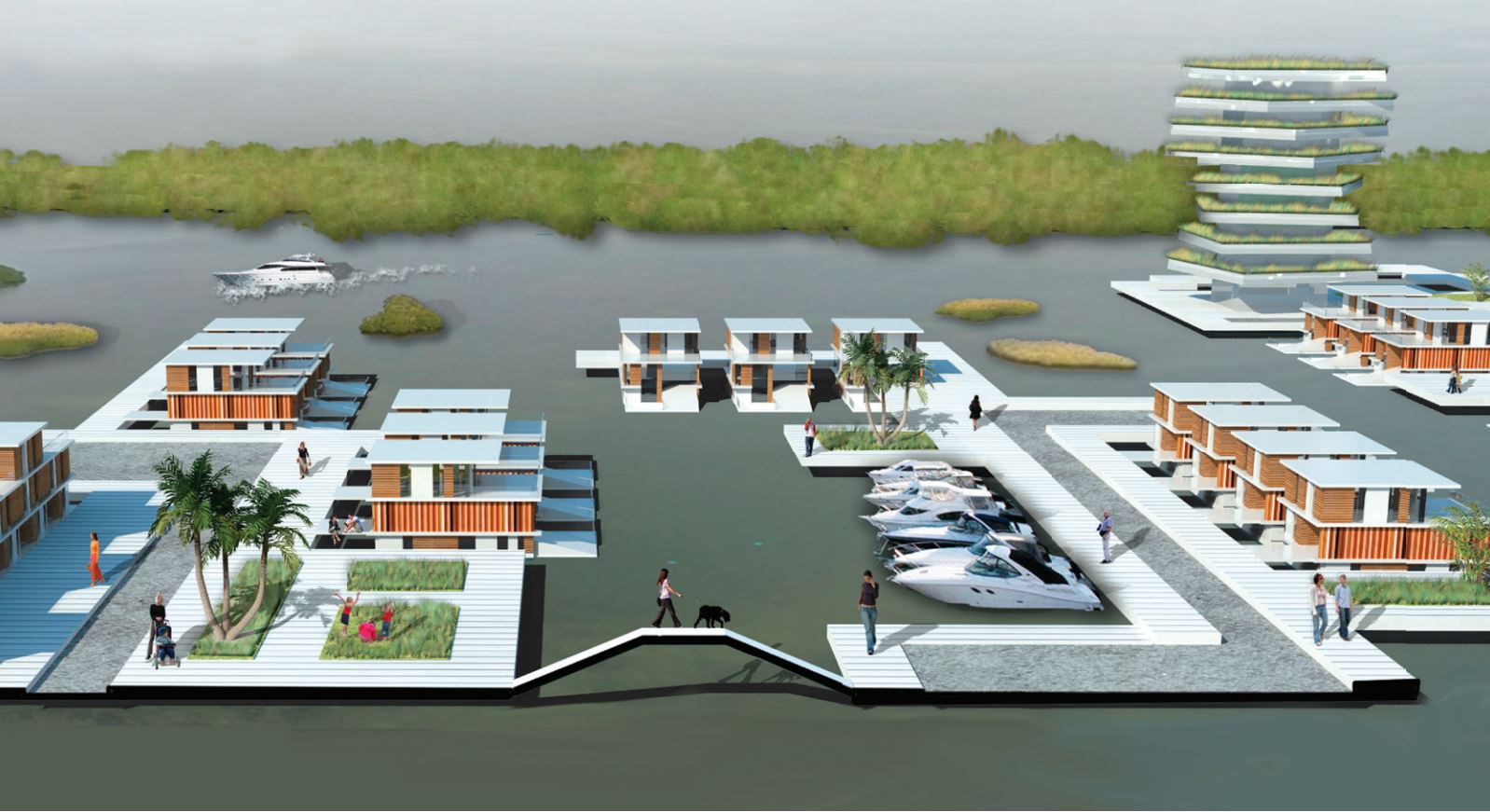
Resiliency Through Floating – Silvia Aloisio
The project is located in the north area of the island, between Longbeach and Whitney Plaza, where a historic settlement will be affected by sea-level rise. This area does not need to be abandoned. Instead, it can strategically grow to provide coastal protection, introducing a new type of resilient settlement that will address sea-level rise.
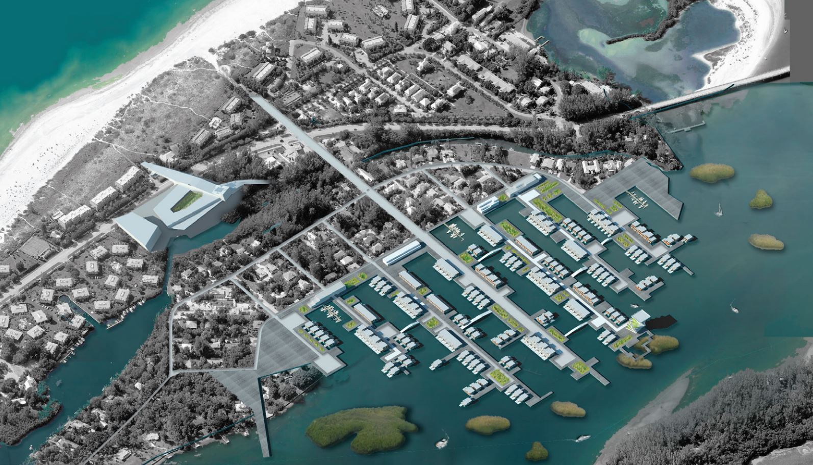
The proposed operation implies the relocation of the inhabitants to different residential floating typologies that will form a new piece of the town that extends itself into the canal. This can happen by maintaining the existing road grid and binding it to the urban fabric of the Key while preserving the identity of the place.
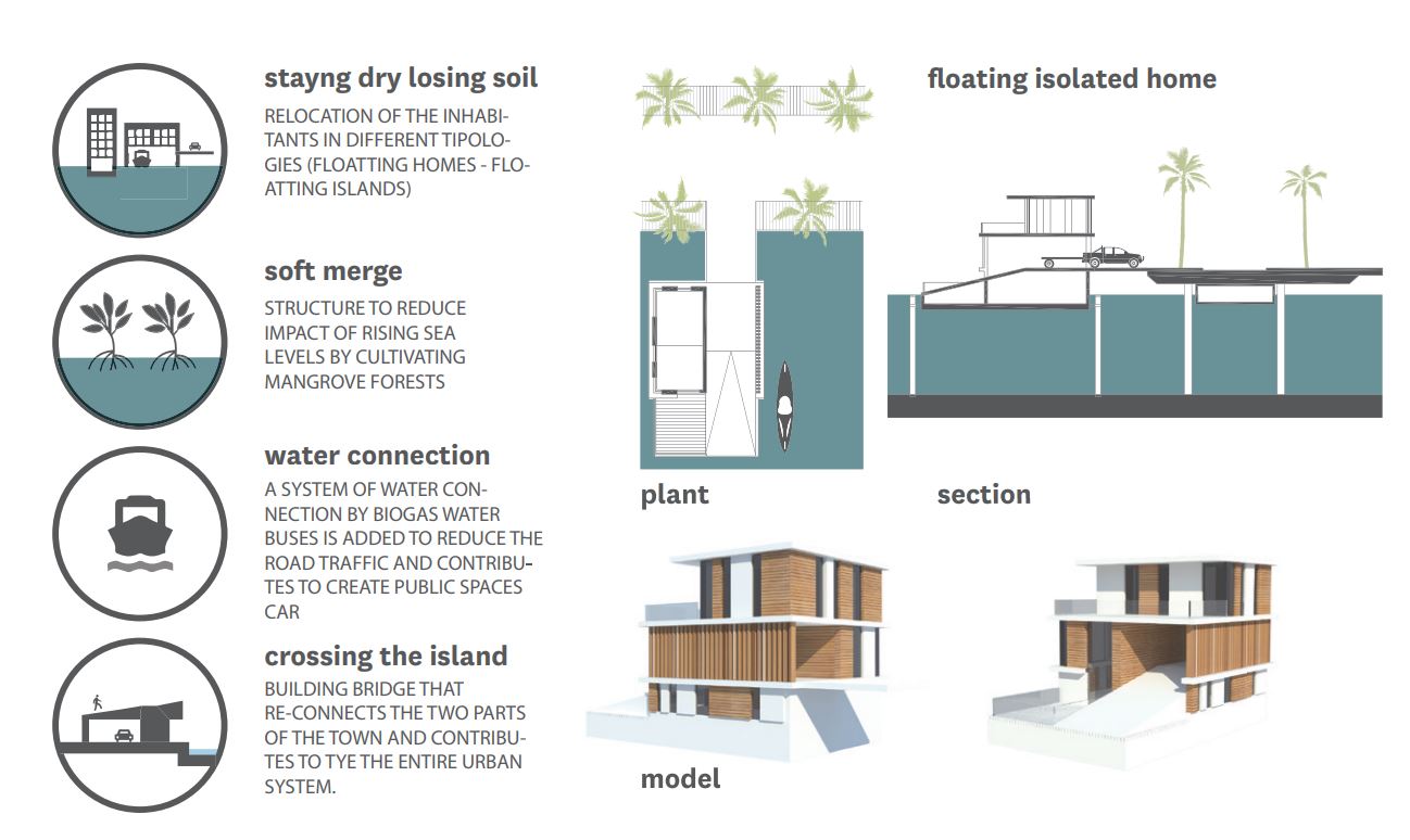
The new residential typology is designed to simplify the relationship of the residence with the water through the introduction of an open room as a boat ramp for small boats that links the street directly with the canal. To defend the island from the threat of sea-level rise, it is also planned to create soft marshes by the mangrove islands that, according to new scientific research, could potentially accumulate and build soil. The new mangroves could be installed as modular structures that, growing, could become a spectacular public waterfront park.
This project includes the redesign of Whitney Plaza, as a new public venue with shops, restaurants, an inner square, a multilevel parking structure, and a garden bridge that links this leisure and commercial point with the beach and becomes a landmark for the north entrance of the island.
Whitney Plaza
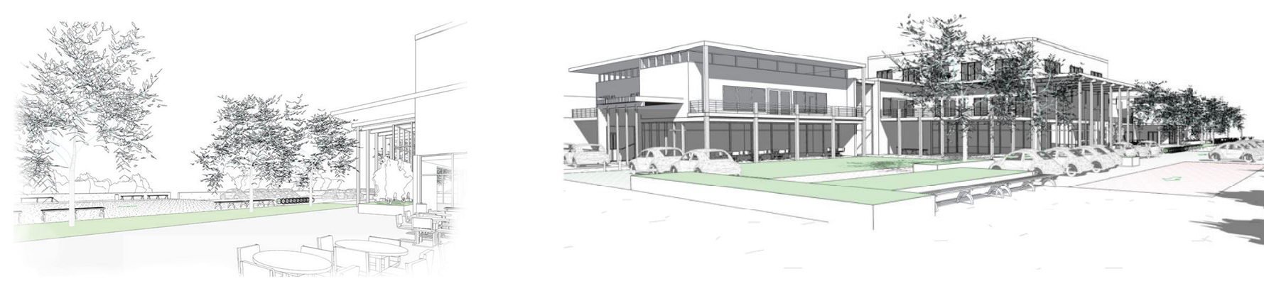
A loosely defined commercial cluster associated with the beach access and the Broad Street and Gulf of Mexico Drive Intersection. This commerce area is in close proximity to the Longboat Key Center of the Arts and is currently located within the Longbeach residential neighborhood. The intersection of Gulf of Mexico Drive and Broad Street is underutilized as a commercial gateway (to the Key, Gulf of Mexico, and Longbeach) and the buildings are currently dated.
Students chose to explore the Broad Street/Gulf of Mexico Drive intersection and adjacent area as landmark entry features for Longboat Key. Perhaps a pedestrian overpass could achieve this while improving pedestrian use of the beach – reducing the need for parking in the beach neighborhood. Land-use regulation should promote and incentivize live-work community forms with mixed-use and mixed demographic development.
Commerce, Living, and Civic Event on the Lawn – Alex Schmidt
Introducing Mixed-Use to a Scenic Environment

Commerce, Living, and Civic Event on the Canal – Shane LaMay
Conceptualizing on Integrated Locus, which creates Place
Commerce, Living, and Civic Event on the Lawn – Alex Schmidt
The project proposes a mixed-use complex associated with commercial venues, residential units, and public spaces. It incorporates the views of an underutilized but scenic bayou. It contains a multilevel car park covered with vines, providing parking for the residential units and the commercial venues.


The residential units are small rental units, located on the second and third levels, intended for use by the peak season care providers. The complex is linked to the beach across Gulf of Mexico Drive. A traffic circle is introduced at GMD to calm traffic by the entrance to the complex and the neighborhood of Longbeach. The civic green space has multiple functions. Under the covered trellis area, public events can be held.
These could include antique and art fairs, farmers’ markets, and more. In another area of the green space, there is a playground for children, and beyond that beach volleyball courts. The civic green spaces also have ample vegetation to provide shade and comfort to the users.
Commerce, Living, and Civic Event on the Canal – Shane LaMay
The objective of this proposal is to provide a civic center – a “downtown core” where people are able to gather, shop, relax, dine, and experience all of the natural beauty that Longboat Key has to offer, by combining separate transportation infrastructure and retail and residential space into one.
The “living street” that connects all of these functions allows for all modes of transportation to travel simultaneously – vehicles, bicycles, and pedestrians all share a common space. Parking for vehicles and bicycles is dispersed throughout the street. The retail shops and restaurants are located along the west side of the street, with the residential units above. The east side of the “living street” is anchored by an eight-foot concrete bulkhead to prevent flooding during storm surges and sea-level rise.
This bulkhead breaks in certain areas allowing people to access a floating wooden boardwalk via a series of ramps. This boardwalk serves as a linear park and buffer to the residences, and meanders through the mangrove forest adjacent to the site.
Gulf of Mexico Drive serves as an essential artery for the island. It runs like a spine up and down a narrow corridor. Neighborhoods are detached from the spine, separated by a vegetative “screen,” so that they are not visible from the road. From the Gulf of Mexico Drive travelers see mostly tropical vegetation and not much of the buildings that lie beyond the screen. This proposal organizes the essential utilities behind a lattice screen that will allow vegetation to grow – creating a barrier between Gulf of Mexico Drive and the parking lot.

Harry’s and St. Jude’s Drive
The commercial area at Gulf of Mexico Drive has ambiguous vehicular circulation logic with repetitive access (curb cuts) leading to multiple pedestrian/automobile conflict points. Limited economy housing exists adjacent to the commercial entities.
There is potential for increased density as part of diverse options for market-driven redevelopment. Explore land use regulations to promote reconfiguration of vehicular circulation/parking efficiency within existing fabric at the commercial area on Gulf of Mexico Drive (near term).

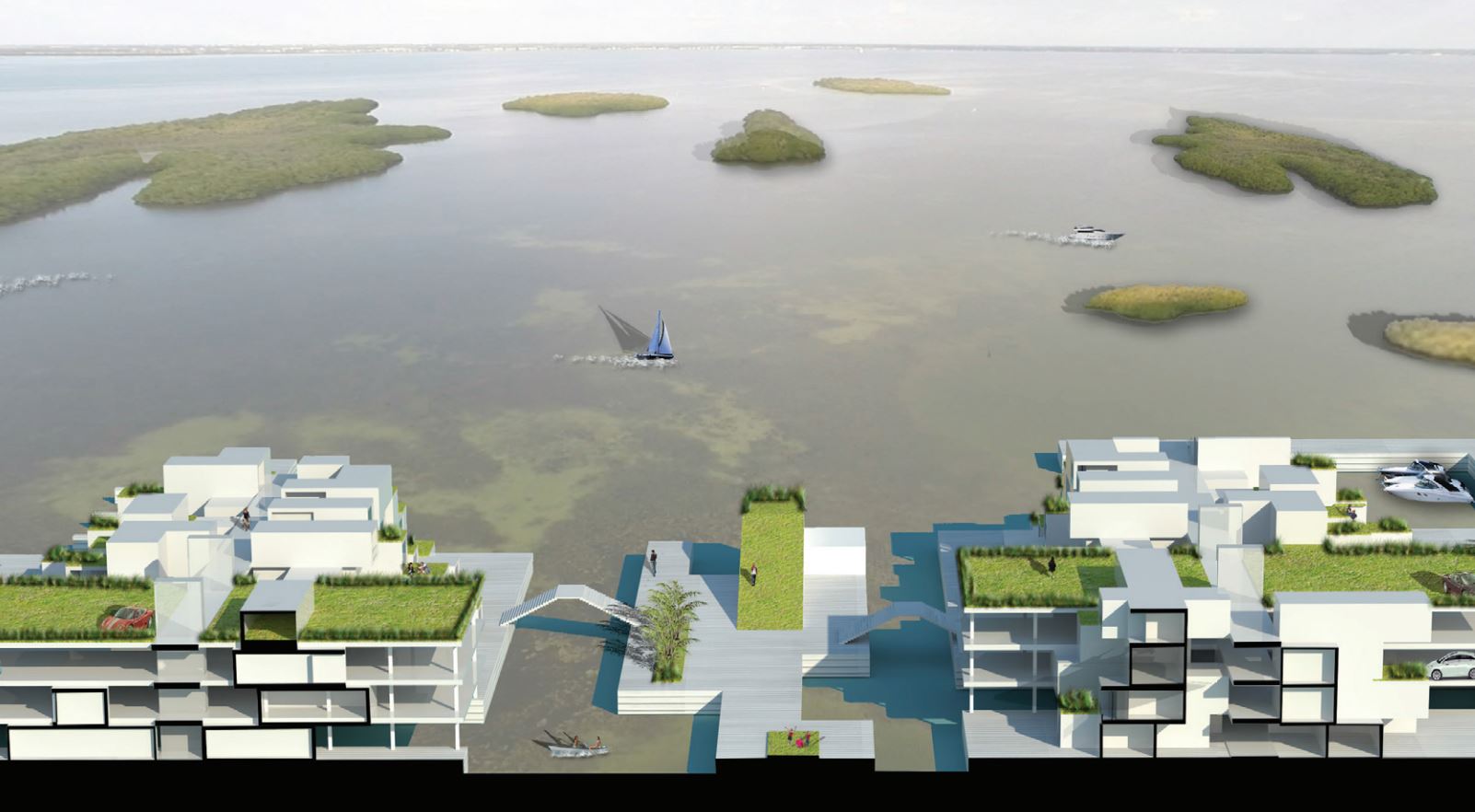
Recombinant Canal Living – Silvia Alosia
Integrating Modular Housing with Vehicular Access and Navigation
Recombinant Canal Living – Silvia Alosia
This project is located in the area of the mobile home park. The site was chosen because this kind of typology is vulnerable not only in respect to the threat of sea-level rise but also to the impact of hurricanes and storm surges.
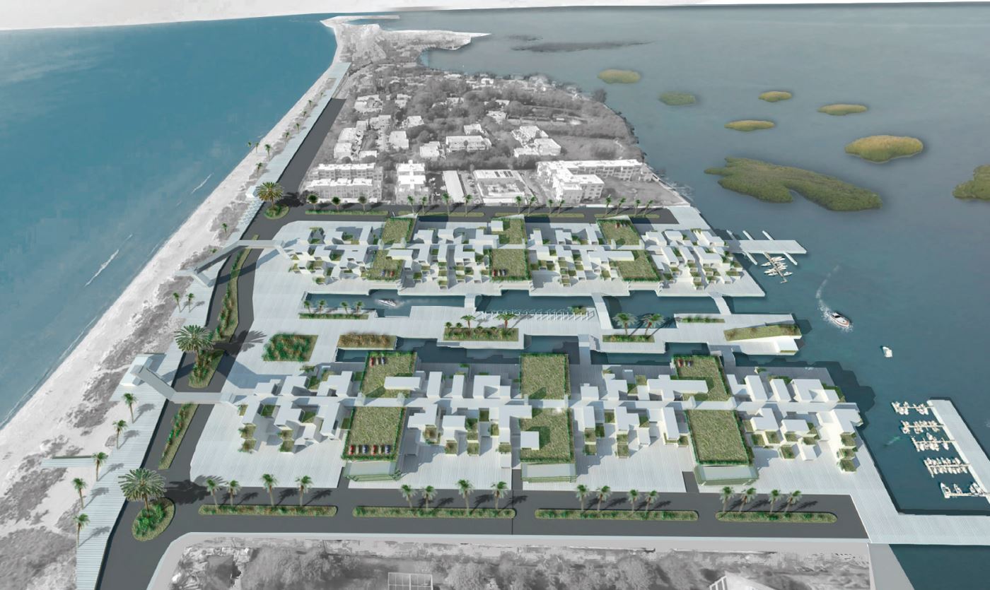
The project worked with the existing urban grid and the prefabricated modules, proposing a new high-density settlement that recombines the canal living, replacing the industrial homes with a modular urban system that has three layers of circulation: one for cars, one for pedestrians, and the last one for boats.
The modular system can grow over time, as mixed-use, with some particular public functions located over the garden roof, such as restaurants and bars, or located close to the parking nodes, shops, or facilities. The new settlement has a central park that creates an inner space that ends with a leisure point and allows double views of the canal and the Gulf of Mexico.
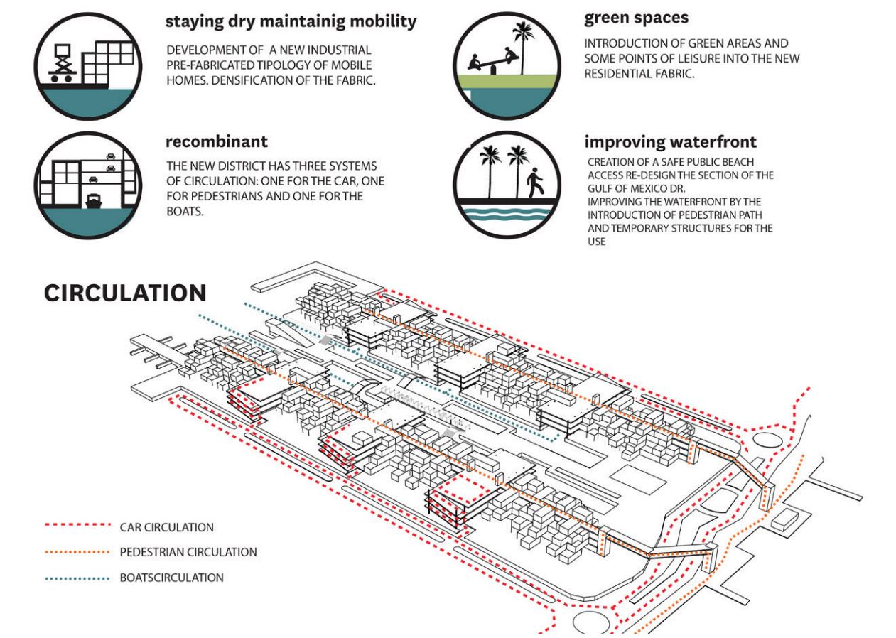
This area is one of the only points of the island where the view is unobstructed to the gulf and the beach is public. This proposal will improve the public waterfront side of the beach, by the introduction of a pedestrian path, bicycle lane, trees, and lightweight shade structures as urban equipment. The waterfront is linked to the new residential fabric by two pedestrian bridges that cross over Gulf of Mexico Drive.
Centre Shops
Approximately 4,000 sqft of commercial space is organized around a well-landscaped parking lot with service parking in the rear. Businesses appear to be well patronized. There is very limited visibility between the shops and Gulf of Mexico Drive.
Students consider linking the Centre Shops of Longboat Key with Durante Park – pedestrian/bicycle access. This can happen by improving cycle pedestrian infrastructure along Gulf of Mexico Drive at this location – shade and perhaps a surface crossing with caution lights or paving indicators. Adding a transit stop would also serve Durante Park with better connectivity.
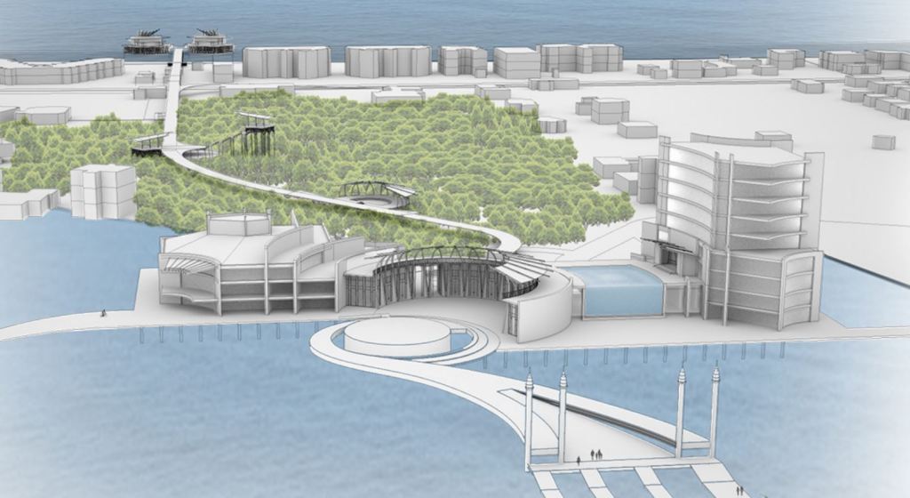
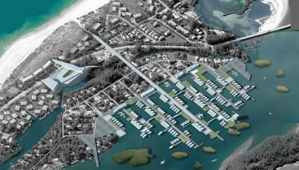
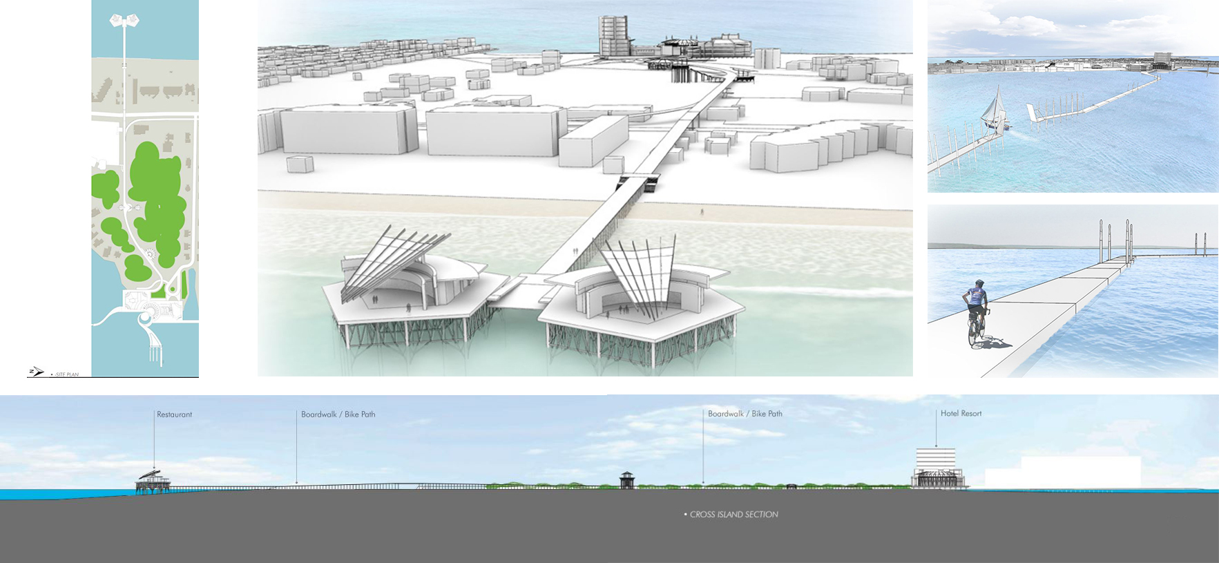
Civic Marina Resort – India Brooks
Cross Island Pedestrian Experience
Civic Marina Resort – India Brooks
The concept is to create a water transportation system, supported also with bike paths and walking paths that will connect public areas in Longboat Key to the mainland, allowing visitors to leave their automobiles in Bradenton.

After crossing Sarasota Bay by boat, visitors will be greeted by an equipped landing, with shops, a hotel, and outfitters. From that point on, their journey becomes a pedestrian or bicycle experience, through boardwalks on the water or over the mangroves. The new landing development and its connections will not only protect the privacy of the current residents, but will also provide new revenue, and new social opportunities for the residents, and bring new life to Longboat Key.

A portion of the boardwalk and bike path will literally take you on a journey inside the bay, opening experiences for pedestrians where only boats could go before. The main segment of the boardwalk is a trans-island crossing that gives the visitors and residents alike unique experiences while moving back and forth across the island towards the beach. At the opposite end of the trans-island crossing will be a magnificent pier that could contain several dining experiences accompanied by the most popular event on the western coast of Florida, the observation of our beautiful sunsets.
Twin Shores
Most homes were built before 1970 but are kept in very good condition. Marina has access to the Intracoastal Waterway system. Direct access and view (across Gulf of Mexico Drive) to the Gulf of Mexico throughout the area. There is an existing community green space, clubhouse, and pool.
The student aims to incentivize newer and more resilient construction types. This may even be considered as a complete redevelopment strategy increasing vertical height (protection from storm surge/flood and improved view) and adding additional amenities at the ground. Improve cycle pedestrian infrastructure along Gulf of Mexico Drive at this location – shade and perhaps a surface crossing with caution lights or paving indicators. Add a transit stop at this location (preferably with15 minute service).

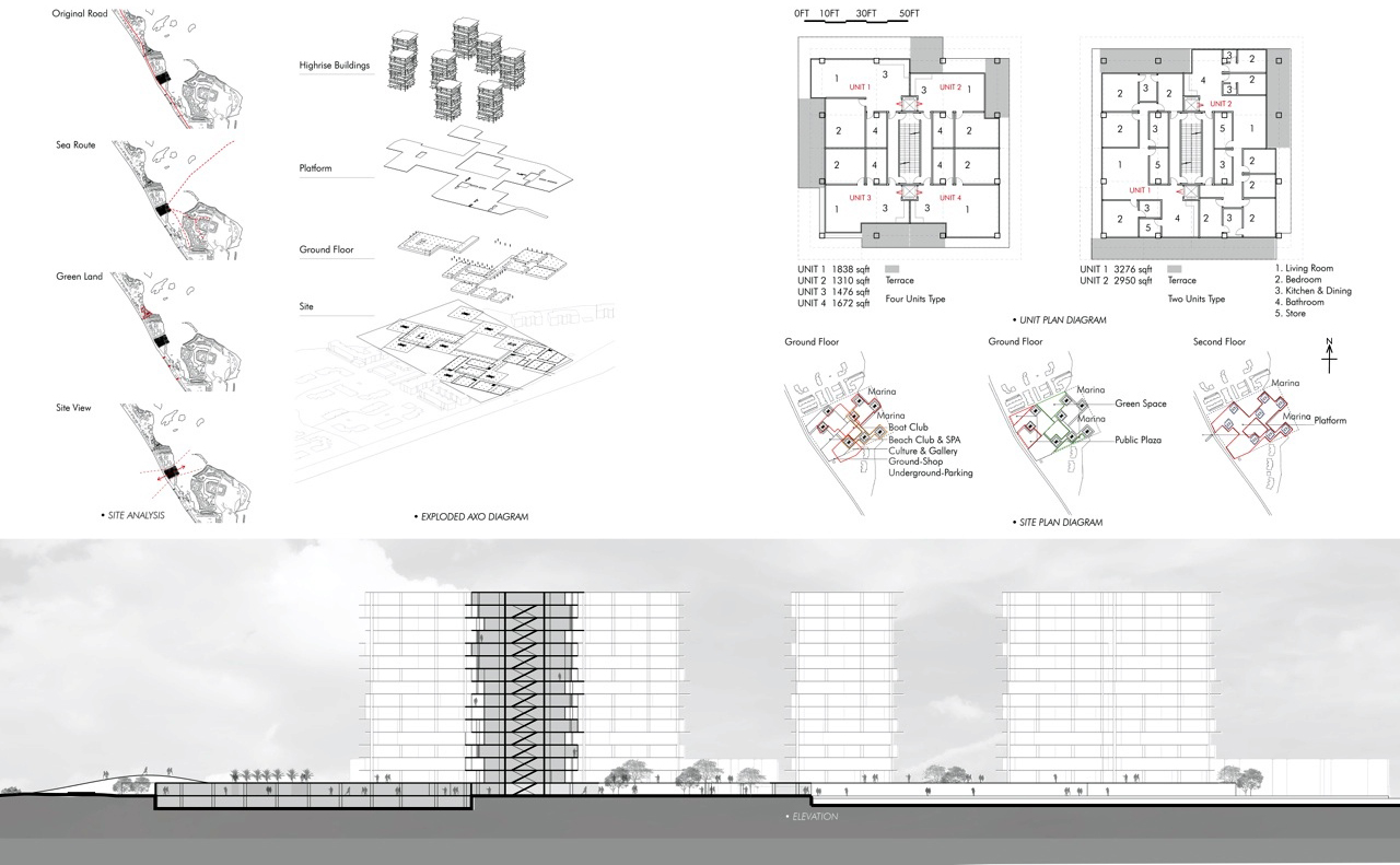
Resilient Podium Community – Di Hu
Density and View-Integrated Complex
Resilient Podium Community – Di Hu
The project is located on the site of the Manufactured home community. It proposes its substitution. Houses in this area are vulnerable and crowded. For providing better living conditions and more public space to residents, a new community sense is created. The site is located in the middle portion of Longboat Key.
The proposed high-rise buildings will give residents a chance to get views of both the gulf side and bayside because the distance between the two sides in this area is quite minimal. High-rise buildings can achieve a density that helps produce more public space. To deal with sea-level rise, the new public ground floor is lifted up to level two. The space on the ground will be used for entertainment, relaxation, and parking. The platform will be as new ground after the sea level rise.
There is a bridge stretched out from the platform that will offer people a way to reach the beach directly by crossing over Gulf of Mexico Drive. On the bayside, the project proposes a marina for the residents’ navigation purposes. The high-rise components of the project are designed following the “8 queens puzzle” in chess to arrange all 8 buildings to make sure they will not shade each other and get the best views. The number of residential units will depend on the market potential for different size typologies, and on code permitting regarding permissible heights. As determined in the project, it is composed of 480 residential units, providing an increase of 50% in residential numbers.
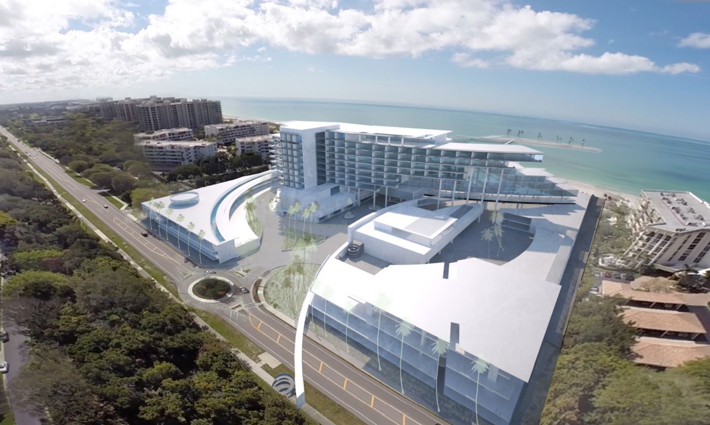
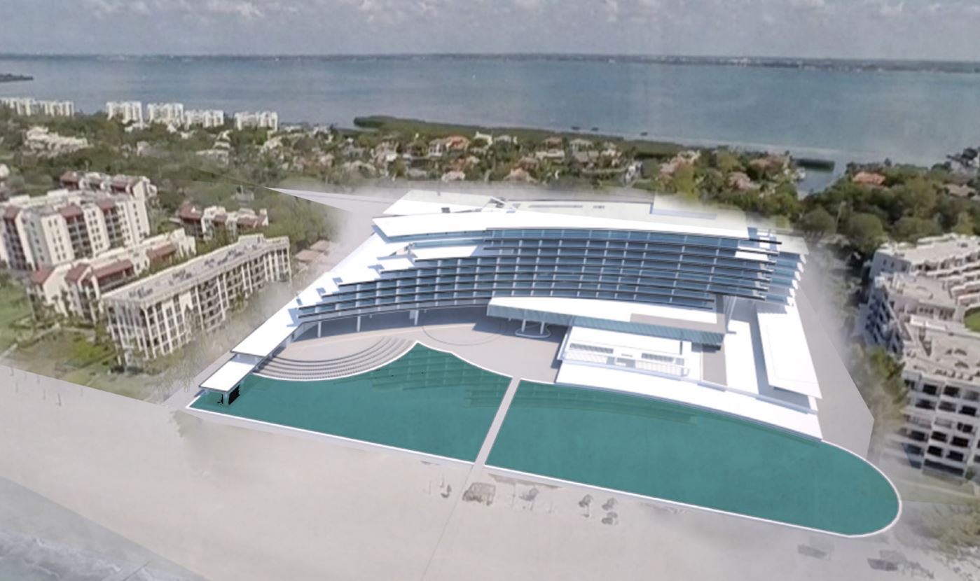
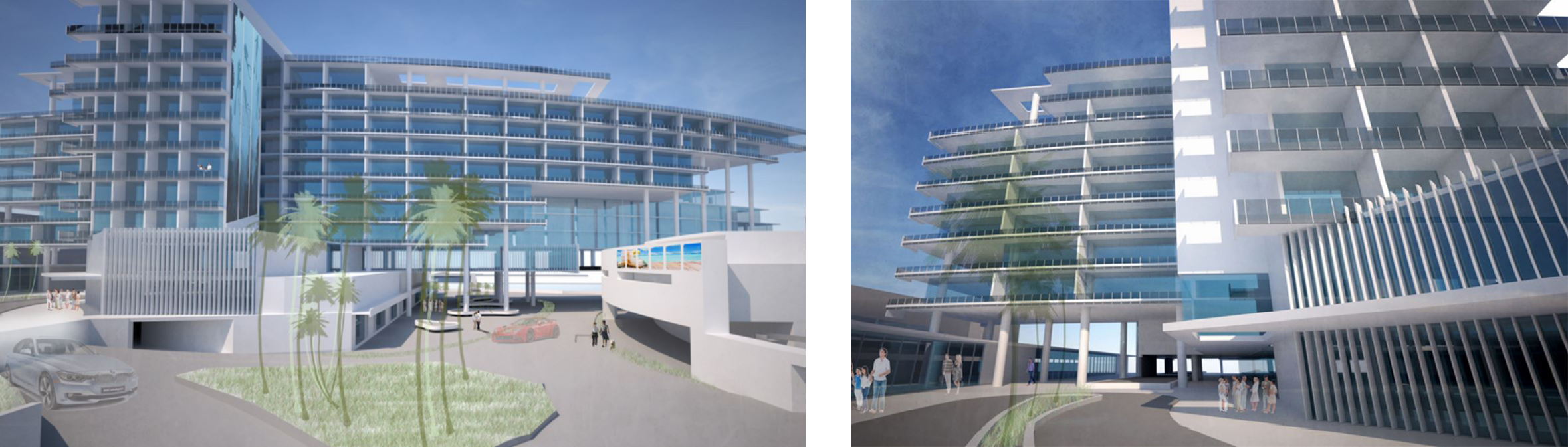
Longboat Key Hilton
Most homes were built before 1970 but are kept in very good condition. Marina has direct access to the Intracoastal Waterway system. Currently features a community green space, clubhouse, and pool. Although there is ample dune and grass, the residents are highly exposed to storm damage given the dwelling construction, and thinness of the key at that location – a quarter-mile (1,300 ft).
Students want to incentivize newer and more resilient construction types. This may even be considered a complete redevelopment strategy increasing vertical height (protection from storm surge/flood and improved view) and adding additional amenities at the ground. Also to improve cycle pedestrian infrastructure along Gulf of Mexico Drive at this location – shade and perhaps a surface crossing with caution lights or paving indicators. Add a transit stop at this location (preferably with a 15-minute service).
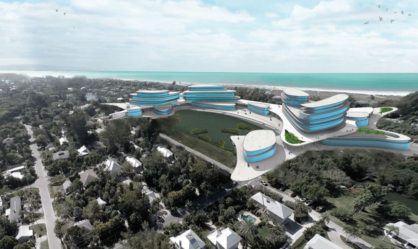
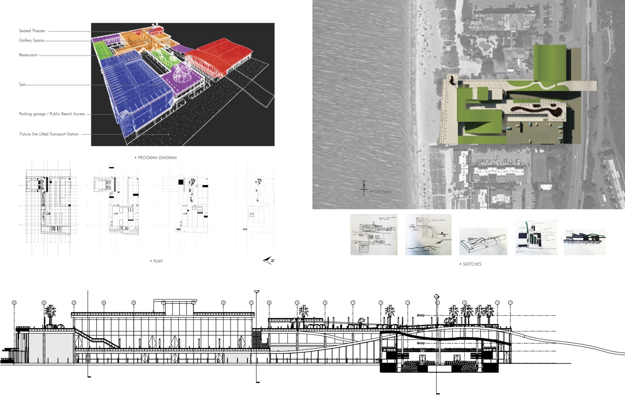
Folding Destination – Matt Kaminsky
Sunset Views
Folding Destination – Matt Kaminsky
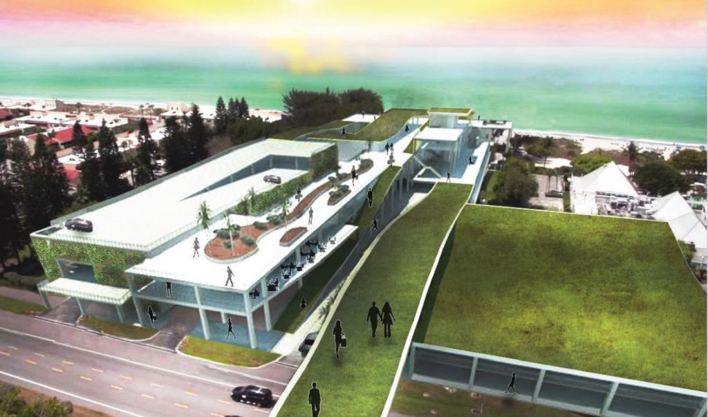
The focus of the third group’s master plan is resiliency in the prospect of change. Following this premise, the site proximal to the current Hilton resort was chosen to create a node of tourism and civic use that will not only survive itself but assist the rest of the surrounding community to become more resilient as well.
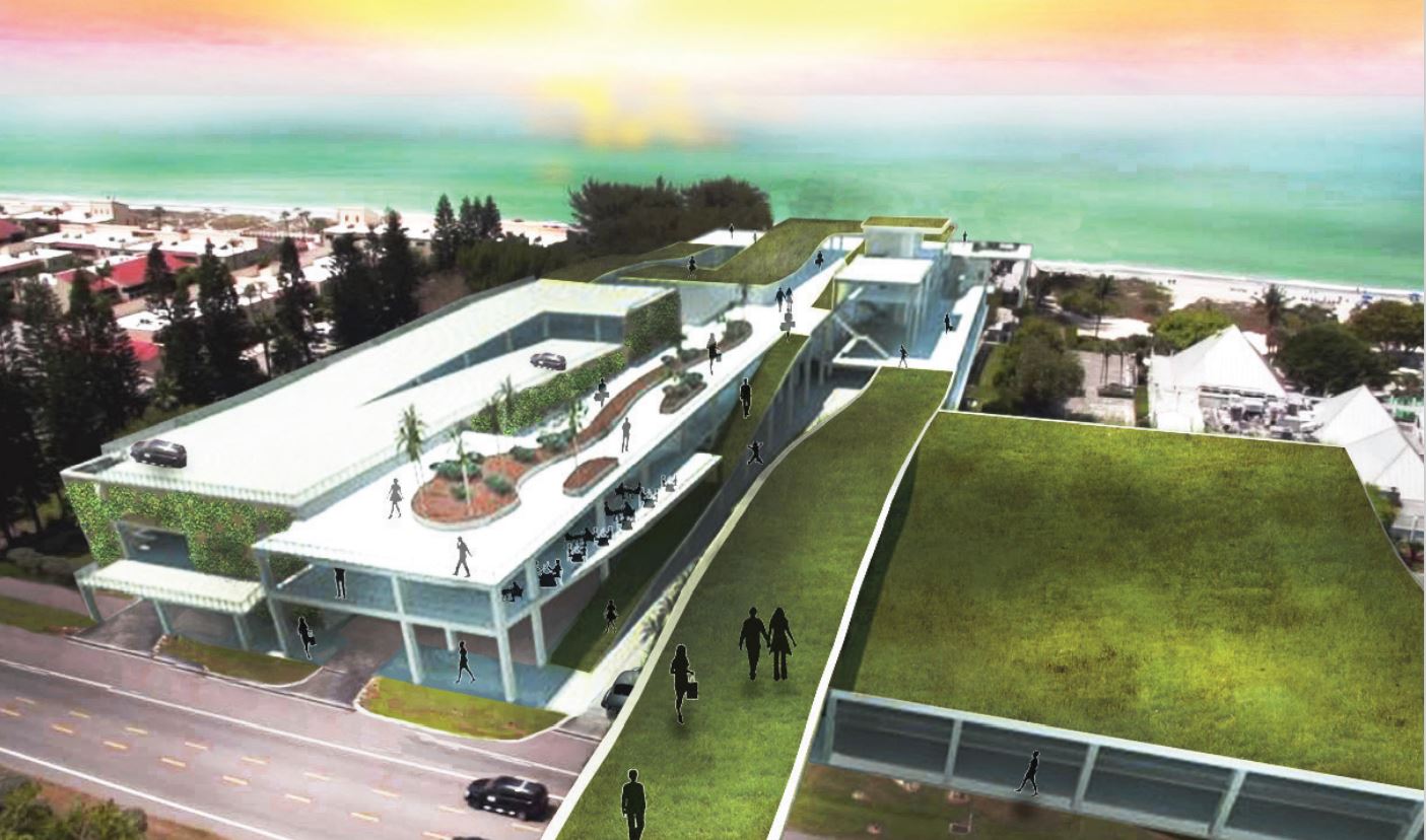
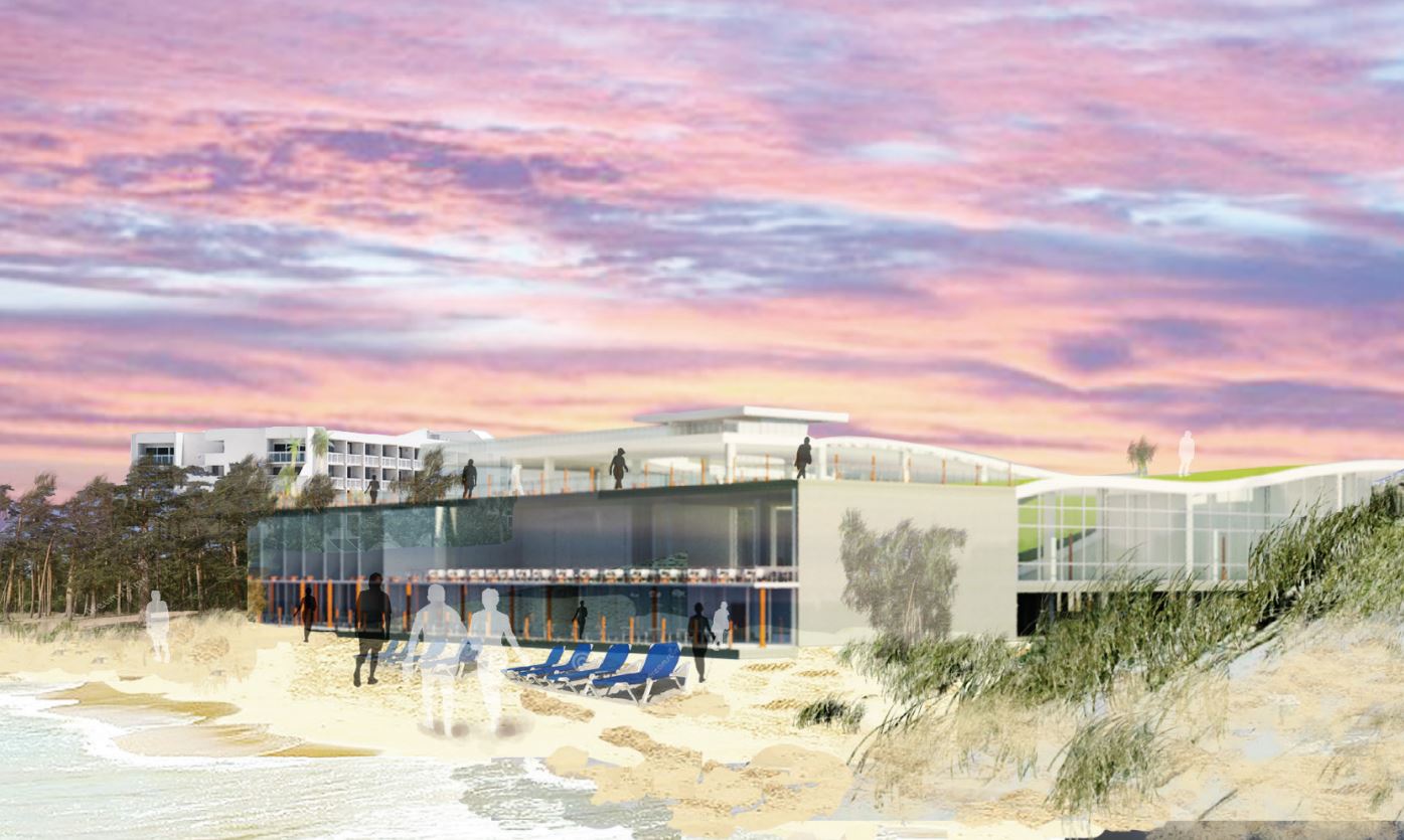
Lifting the ground plane allows pedestrian interaction and avoids issues caused by future inundation. It also prepares the site to benefit from a lifted transportation system that will increase connections not only along the key nodes identified in the master plan along the Gulf of Mexico Drive but also on the mainland – increasing diversity of use and destination – while also creating an island more stable in the face of change.
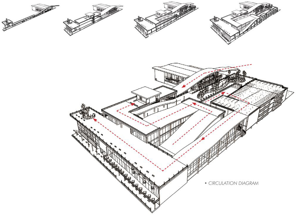
The site also functions as a connection between the different assets of the island – bay, and gulf – as well as natural and manmade. This project brings commercial, cultural, and technological resiliency with new art galleries, public beach access, commercial use, a spa and restaurant boardwalk along the gulf beach, and a new event center. The architecture arranges itself to maximize access to the west horizon and sunset views by lifting up near Gulf of Mexico Drive and gradually meeting the beach. This centralized node of tourist destinations will also provide social resiliency as tourists will have a single destination for beach access and restaurants with horizon views, diminishing the need to travel throughout the private areas of the island.
Bayfront Park
Currently in the redesign phase (master plan concept) as a joint Town of Longboat Key and Sarasota County project with an expanded footprint to the South and North. Current activities include a recreation center, youth baseball field, and tennis courts among others. Current plans call for substantial expansion to the north and south. Renovation priorities include a rebuild of the current pavilion, an open pavilion, a kayak launch, lawn sports (bocci, bowling, croquette, putting), expansion of ball field (adults), picnic facilities, children’s playground, dog park, and lap pool.
Students begin to consider the pedestrian overpass between Bayfront Park and the Beach. Explore optimization of design for enhanced and expanded uses – civic events. Park proposals reviewed as part of this report could be more expansive in their vision – consider an enhanced civic pavilion and an organizational strategy that optimizes views of the bay. This could include structures on the bayside.
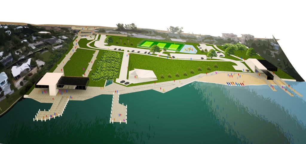
Modified Confluence – Alexander Thomas
Recreation and Civic Node
Modified Confluence – Alexander Thomas
This project examines the island and its culture as an economy of diverse ecologies – not only natural ecologies – but also recreational, civil ecologies and social ecologies. Viewing the island as a series of imbalanced ecologies allowed this peaceful site to become a modified confluence of recreation, nature, and social interaction, in order to ‘balance’ the system.

Bayfront Park is unique with its potential to serve as the ligament – to become the connective tissue – joining the bayside to the gulf, giving rise to an architectural folly to carry individuals over Gulf of Mexico Drive to the beach. In addition, a new recreation center provides views directed outward over Sarasota Bay, fronted with a lawn that creates a moment in nature for hosting formal or informal events.
The new park design also includes a nature center and a kayak outfitter to provide guided nature tours and small craft rental, and a pavilion and sculpted grass seating area are created for open-air concerts. The proposal is developed in two stages, with the first one working around two existing commercial venues and the second phase proposing commercial relocation to some of the other commercial hubs on the island, and allowing for park expansion and greater visibility from GMD.
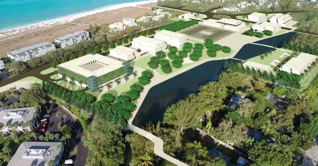
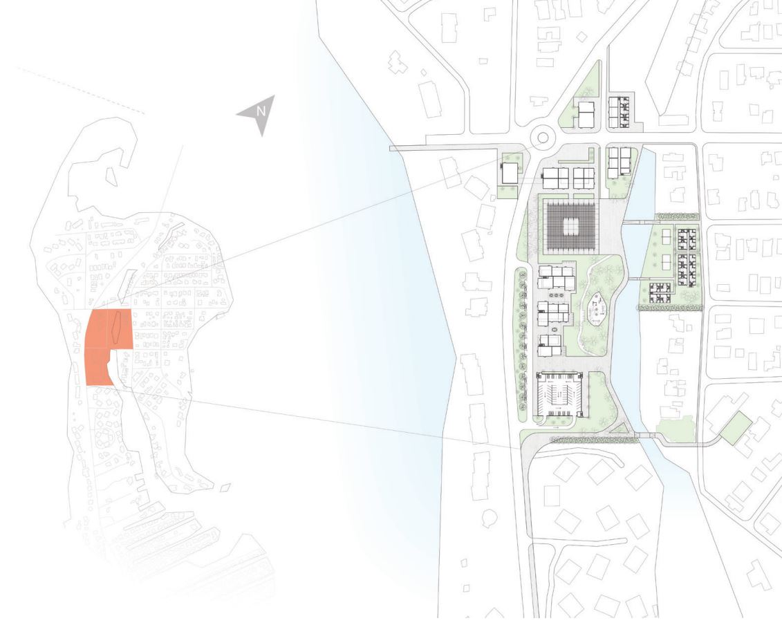
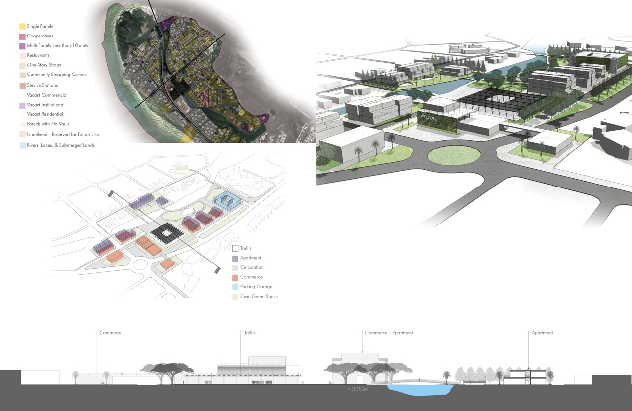
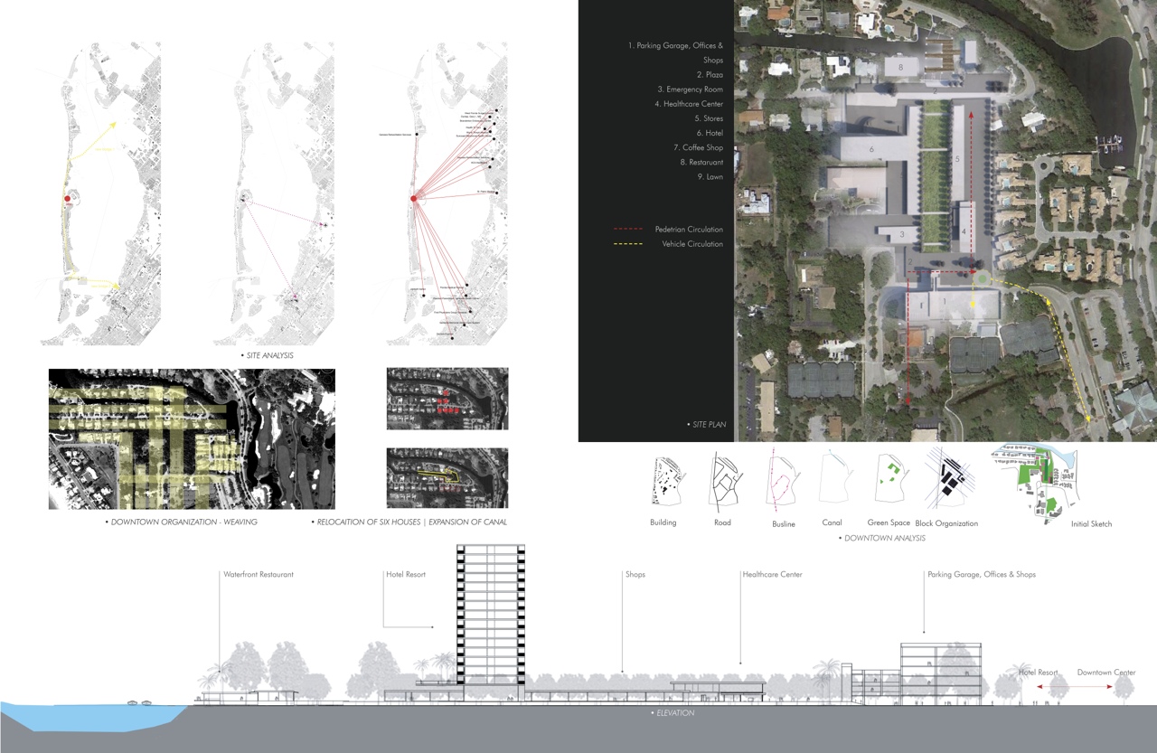
Town Center
Includes the post office, library, recreational tennis facilities, and the Publix/CVS shopping area among other commercial enterprises. There is a mix of civic, cultural, recreational, and commercial uses. The town center is nominally 45 acres in area. There are two vehicular access points to the main arterial Gulf of Mexico Drive – Bay Isles Parkway and Bay Isles Road providing a ‘loop’ traffic configuration.
Students develop a clear hierarchy for organizing the entire downtown – main and secondary streets. Establish build to lines rather than setbacks. Sidewalks should be ample and provided on both sides of the street. Take advantage of the ‘loop’ organization to optimize commercial interaction – this avoids end turnarounds and lets people engage from many different points

Healthcare Resort and Civic Plaza – Hsiao-Tung Hung
Urbanizing Downtown
Water Scape and Urban Canal – Silvia Aloisio
Creating a New Atmosphere
Healthcare Resort and Civic Plaza – Hsiao-Tung Hung
The project is a mixed-use program in the downtown area near a canal at Inner Bay. The program contains a healthcare center, an emergency room, a fifteen-story hotel resort, with a rooftop restaurant overlooking both bay and gulf views, a shopping center, a waterfront restaurant, and a waterfront coffee shop.
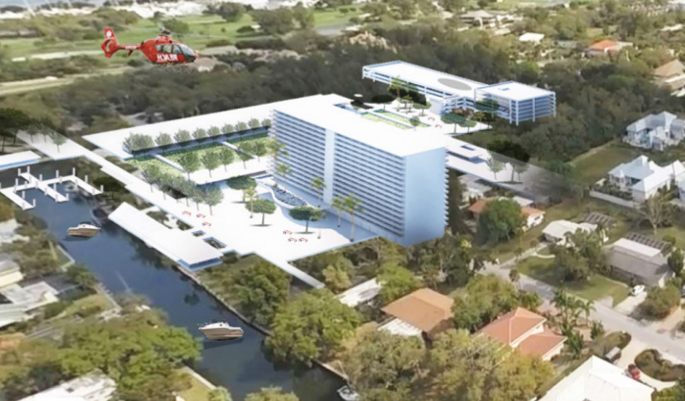
The program also contains a multistory shared car parking building over commercial venues that provide a link to the future renovated downtown. The goal is to add needed programs for the Key and to revitalize the current town center area, bringing it to the full potential of a civic space while providing healthcare to locals and visitors.
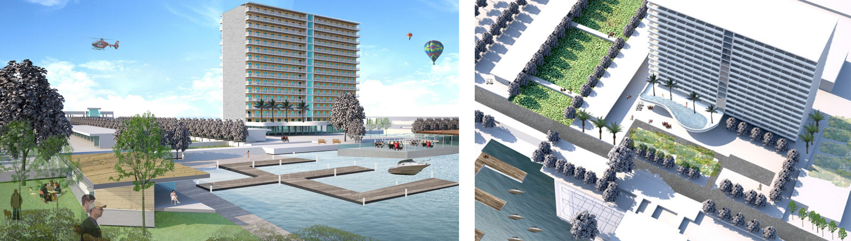
These varied programs are organized around a central lawn, connecting North to the Marina, and South to the commercial town center, following a weaving pattern of the downtown organization. Both residents and visitors could come to the health resort for vacation while having a checkup or scheduled procedure. It is a combination of healing and enjoyment.
The resort also includes an emergency room which provides the emergency health service that is currently lacking on the island. A helicopter is provided to transport patients to the mainland if needed, with the heliport located on the rooftop of the garage.
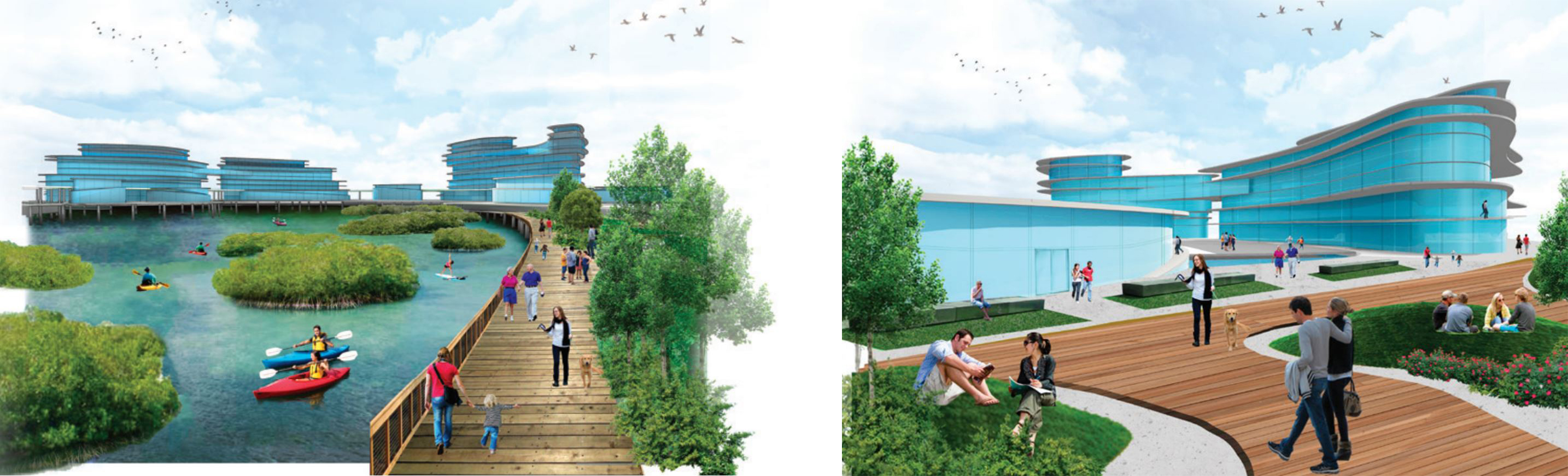
Water Scape and Urban Canal – Silvia Aloisio
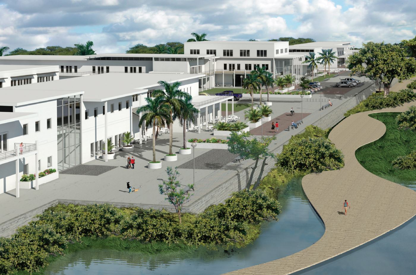
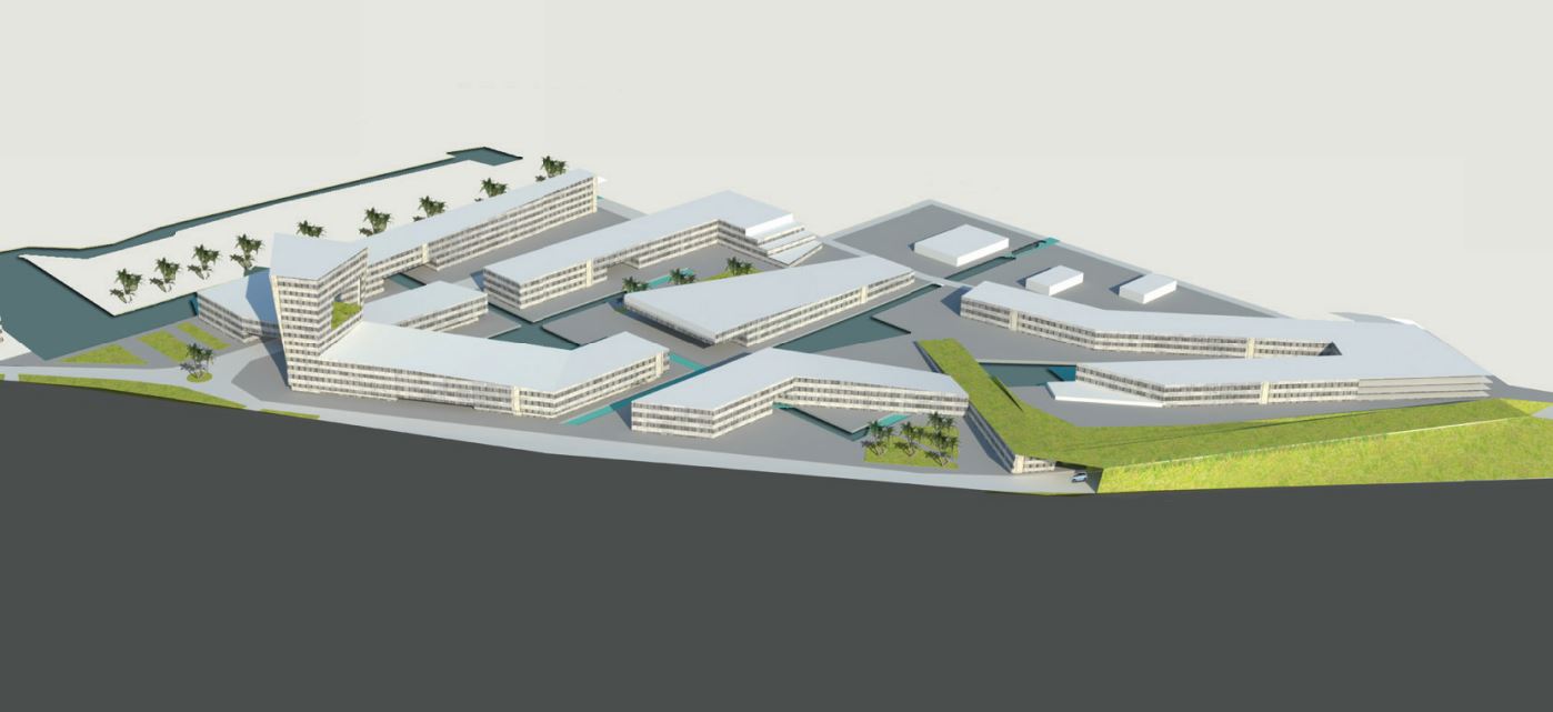
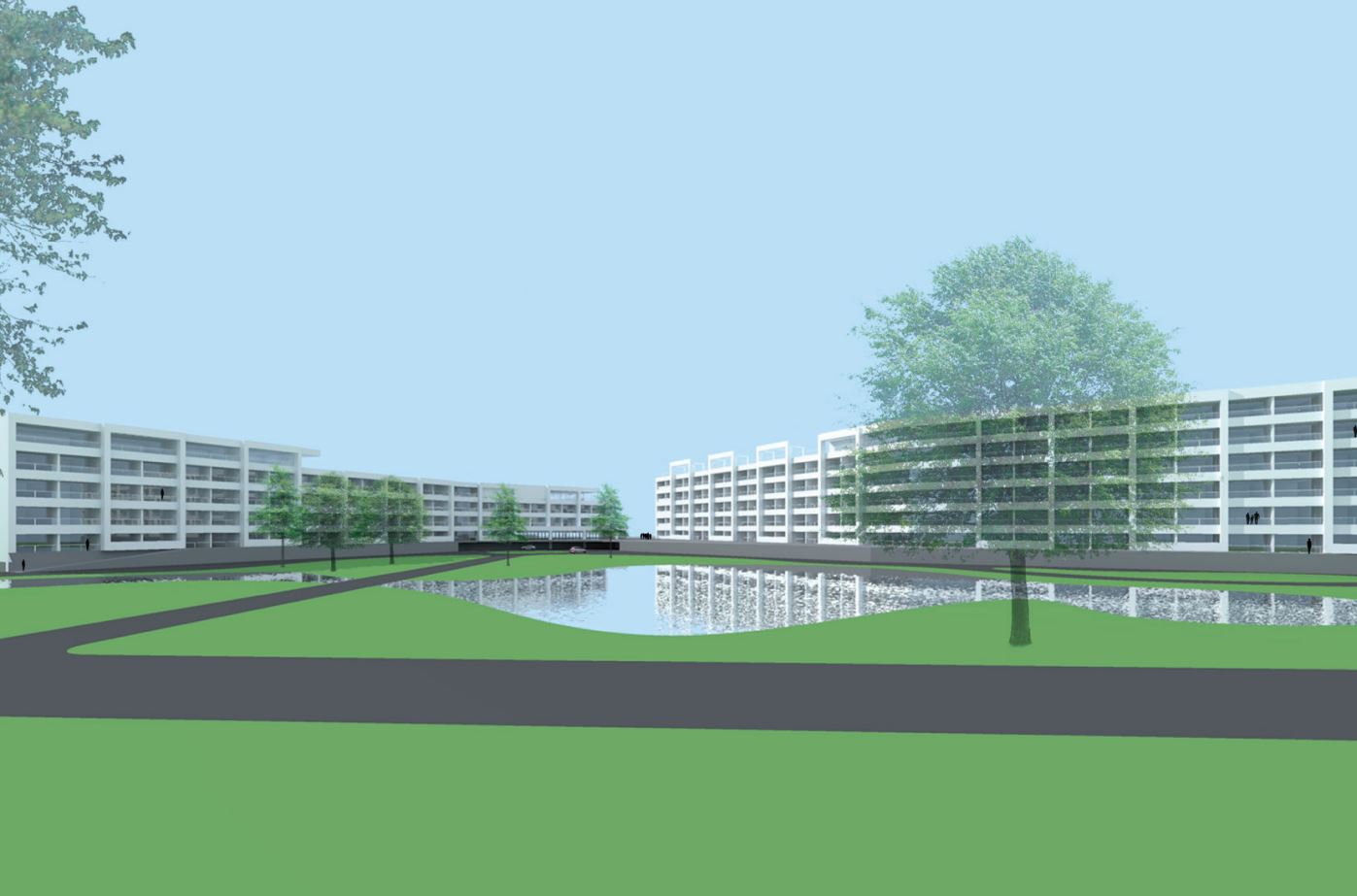
This proposal refers to the Longboat Key town center, which now is a lifeless aggregation of facilities and parking without urban identity. Proposed is the creation of a new pedestrian center with shops, restaurants, housing, public utilities, and a theatre. The center will identify itself as a waterscape.
The water is extended through canals into the town to redesign the public space, giving an urban quality and identity that is now denied. These canals have two other functions: the first one is contributing to the natural refreshment of the buildings, composed of the green external areas buffer zones; and, the last one, controlling and managing the sea level rise through elevation and retention ponds. The core of the new town center is car-free and the vehicular circulation surrounds the area and is equipped with multilevel parking facilities at the two opposite corners of the site.
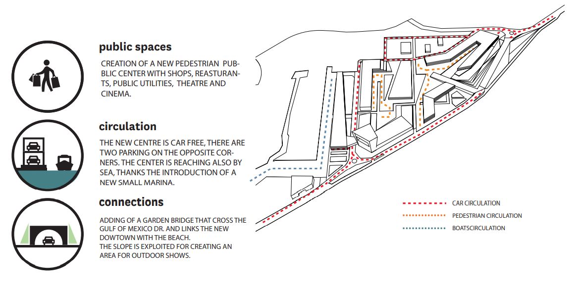
The center is reachable also by the sea, through the introduction of a new small marina and the water connections by the water buses. In the south end of the area, the path of the Gulf of Mexico Dr. is modified, dividing the circulation into two streets. Gulf of Mexico Dr. enters a gallery, adding a park bridge that links the town center to the West side of Gulf of Mexico Drive, while the local circulation that goes in parallel to Gulf of Mexico Dr. outside the gallery, gives access to the town center. The slope, created by the bridge can become an area for outdoor shows.
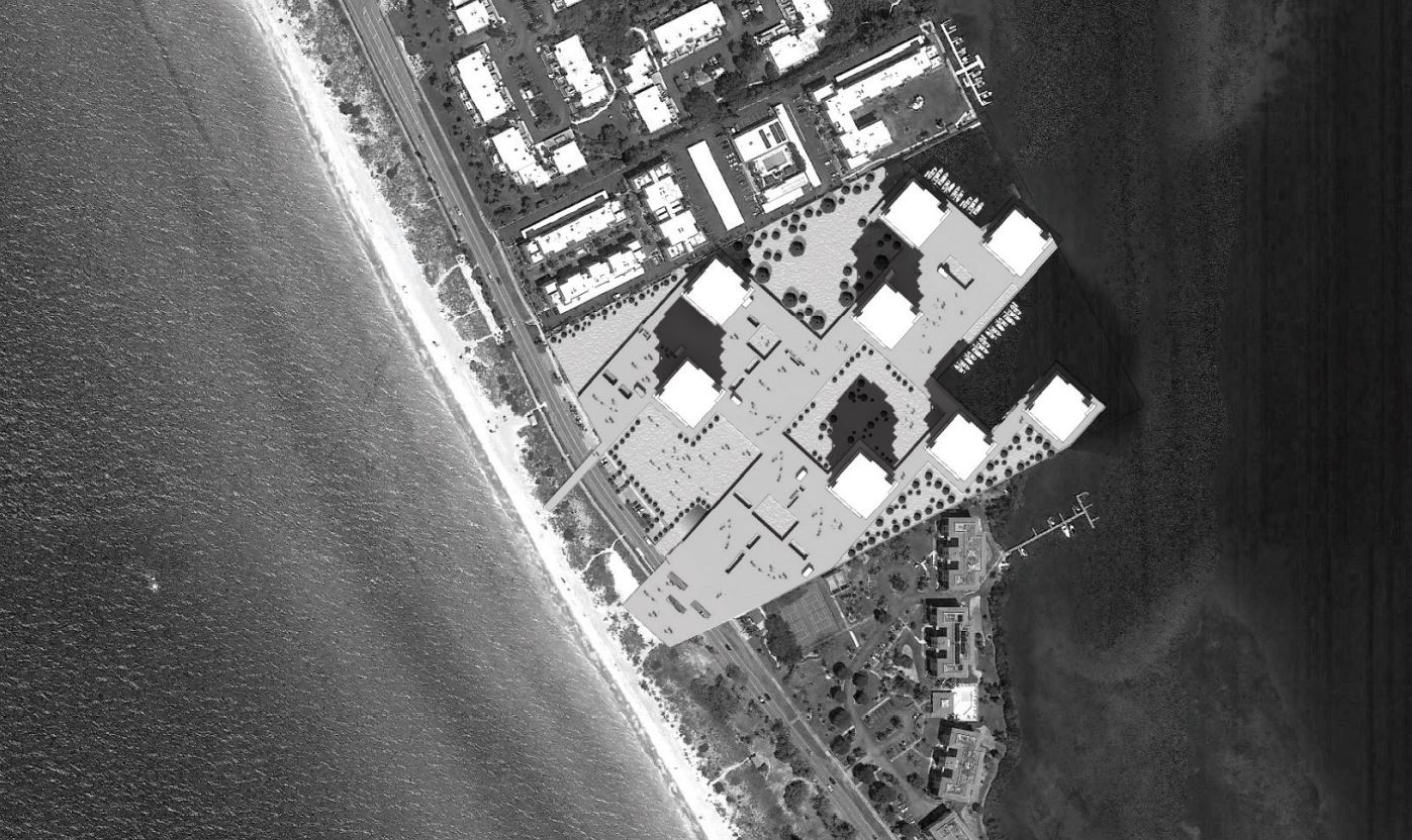
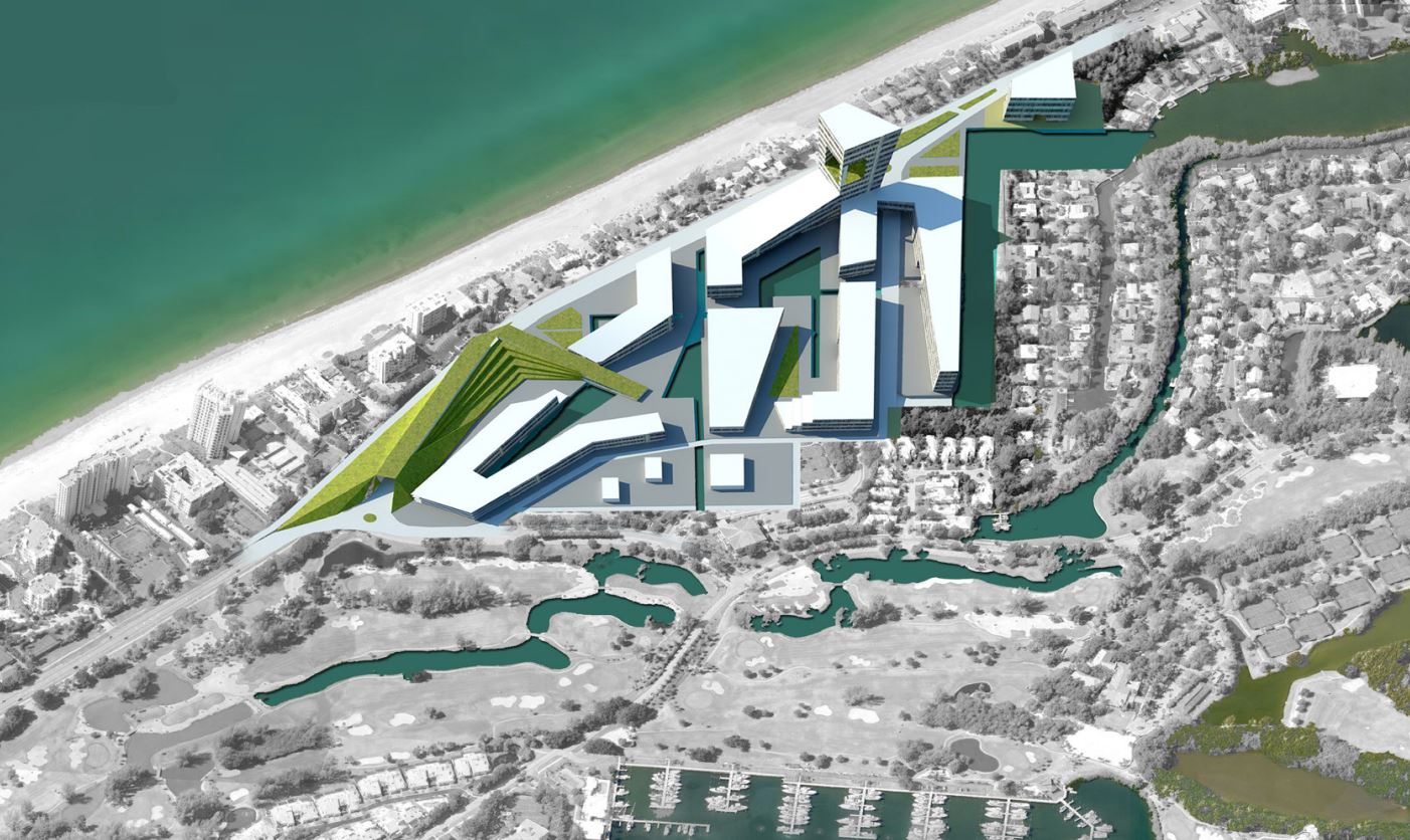
The Colony
An abandoned 273-unit beach and tennis resort on the Gulf of Mexico. The site measures approximately 19 acres with almost 900 feet of beachfront and over 900 feet of depth between Gulf of Mexico Drive and the Beach. The existing structures include frame and masonry construction that are quite outdated in terms of code compliance and marketability. They are likely not salvageable given the code issues and degradation since they have not been inhabited for an extended period of time.
New and redevelopment on the beach should also supply resources for beach renourishment – this should be codified as a long-term infrastructural cost. The notion that redevelopment must take the exact form as the current development is clearly problematic in this precedent case. That notion within Longboat Key and Sarasota County will need to be challenged to avoid a coast of condominium ruins.

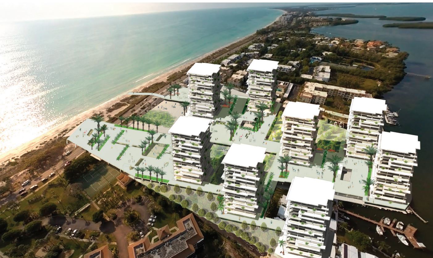
Resilient Resort – Emily Porter
Flood Resilience

National Tennis Training Resort and Stadium – Lauren Day
Sporting Experience

Reef Resort at Longboat Key – Craig Nightingale
Reconstructing the Beach
Resilient Resort – Emily Porter
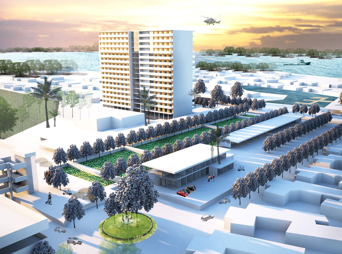
The Colony will be a new hotel resort on the Park and Ride System from the proposed master plan giving public beach access and amenities. The hotel resort has a total of 475 rooms of varying sizes as well as 20,000 square feet of conference space.
The structure is elevated to allow cars to park underneath the structure. The raised structure also provides an elevated public plaza that begins to terrace down to the beach, giving visitors public beach access. The plaza gives a total of 35,000 square feet of public outdoor space. The public can also access a rooftop restaurant with views of the Gulf of Mexico.
The raised structure also serves as a sea wall to protect the building and the site from the eventual sea-level rise and storm surges that have been predicted. Once Longboat Key has been flooded over decades, the sea wall creates a protected water feature on the bayside of the site. This space can be dredged and used as a small marina that can allow boat access to the site even after the severe conditions in which we could expect the site to be flooded.
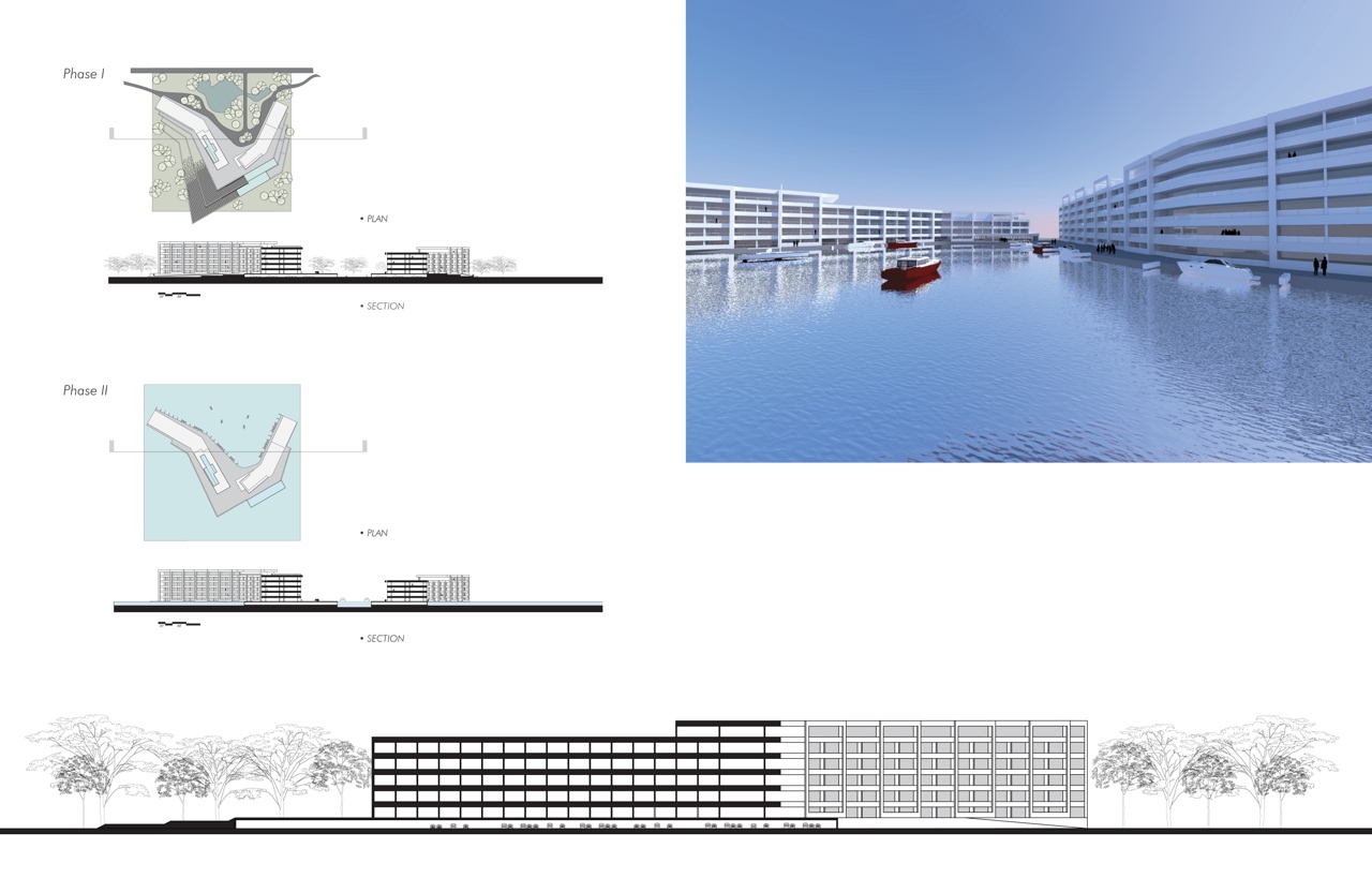
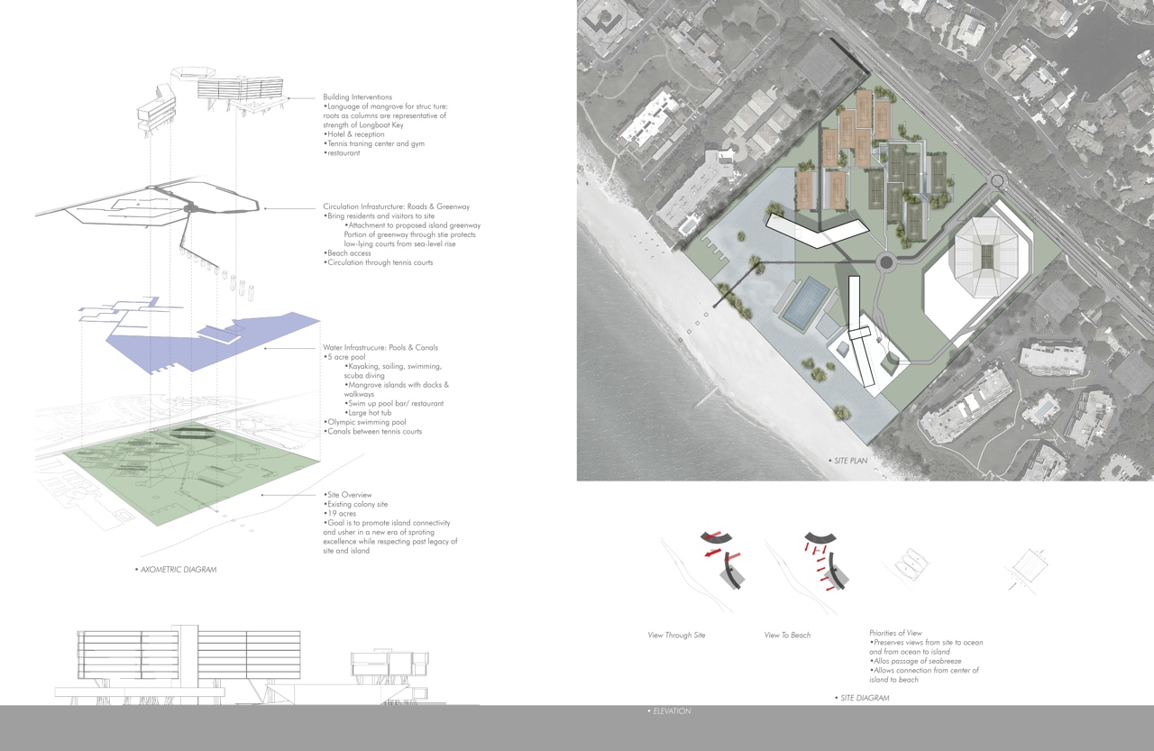
National Tennis Training Resort and Stadium – Lauren Day
The National Tennis Training Resort and Stadium on the former Colony site seeks to rejuvenate Longboat Key’s affiliation with sporting excellence. Used as a winter training site for many professional tennis players, like Andre Agassi in the 90s, the Colony was a true icon for tennis in Longboat Key.
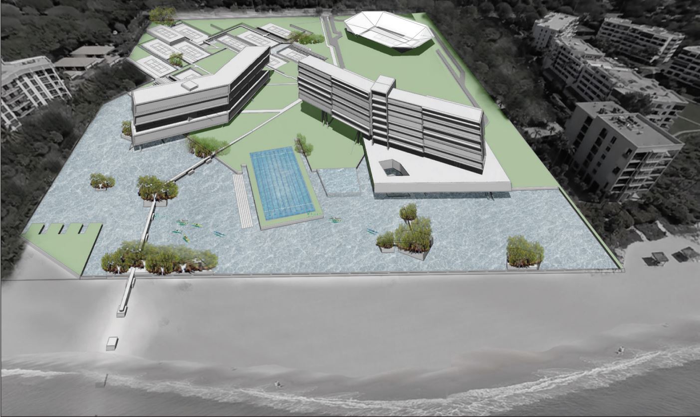
The new training center and the stadium will restore the image and excellence while retaining the historical connection to its origins. The stadium will bring elite players from around the world to the Key, creating new brand recognition for the Key as a place of sporting excellence.
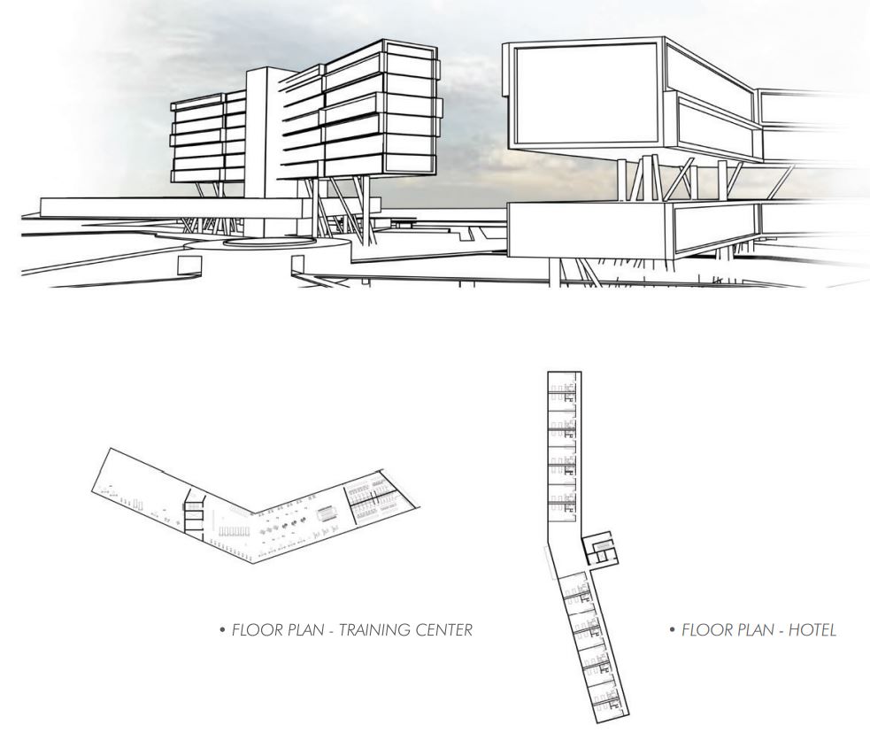
New tourism will be introduced by adding a resort element with a five-acre pool, making it a one-of-a-kind destination in the United States. To bring the other residents and visitors of the island to experience the site, the proposed island greenway will move through the site with beach access available. High-end restaurants will also serve the resort and training center guests, as well as the other islanders.
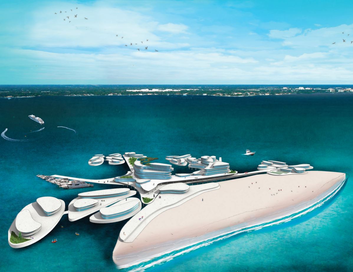
Reef Resort at Longboat Key – Craig Nightingale
The Reef Resort will construct a protecting reef that will host marine life and protect the beach from erosion. The Reef Resort at Longboat Key will be defined by three main buildings and several supporting facilities placed throughout the site. Replacing the Colony development, the proposal develops the site with added intensity.
The hotel rooms cantilever from the central axis and are designed to provide suites with large outdoor spaces and private pools. The curved form creates optimal views for guests: the West guest suites look to the Gulf and the East guest suites watch the sunrise over Sarasota Bay. Careful thought was used while designing the procession from the entrance to achieve views combined with a clear organization and ease of movement.
From Gulf of Mexico Drive, there is a clear sightline under the cantilever revealing the horizontal edge of the ocean and the first glimpse of what appears to be an island. To the right is a parking garage for day visitors, the left is for guest parking located under the hotel, and continuing toward the ocean will lead to a turnaround, that reveals the largest saltwater pool in Florida. The pool will stretch 1000 feet along the coastline acting as a seawall, will provide resistance to future sea-level rise, and will allow for a boardwalk leading to the beach. If traveling from the island bike trail there is an overpass that moves across Gulf of Mexico Drive and slides into the health spa. 80,000 square feet of indoor meeting space is provided, catering to groups of all scales and types, from executive board meetings to large-scale conventions.
Retail shops occupy the ground floor and entrance to a two-story 30,000-square-foot health spa. Vertical circulation and an atrium are located in the main tower that rises above the lobby level. Three restaurants are located in the hotel, one on the top-level showing off panoramic views of the Key both from indoor and outdoor spaces. A third restaurant is located under the ocean surface nestled in the artificial reef and man-made beach, providing innovative programs to make a world-class destination.

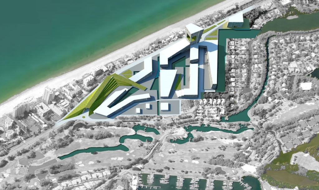
South Key Threshold
This prominent location was selected as the site of Sarasota’s first Ritz Carlton Hotel unfortunately was abandoned during construction. Even though the project was not completed, it played an important role in establishing Longboat Key as an important luxury vacation site. The existing buildings include masonry structures and currently abandoned tennis courts. The Longboat Key Club seems to have relocated its tennis facilities north within the Bay Isles property.
The site also provides opportunities for access to the nature walk. The site offers the opportunity for panoramic views from an elevated location – a key feature of the original Ritz Carlton hotel design. New development could be regulated through floor area ratio (FAR) rather than by dwelling unit per acre (dua) to allow for temporary tourist occupation without compromising limits on dwelling units – typically for permanent residential dwellings.
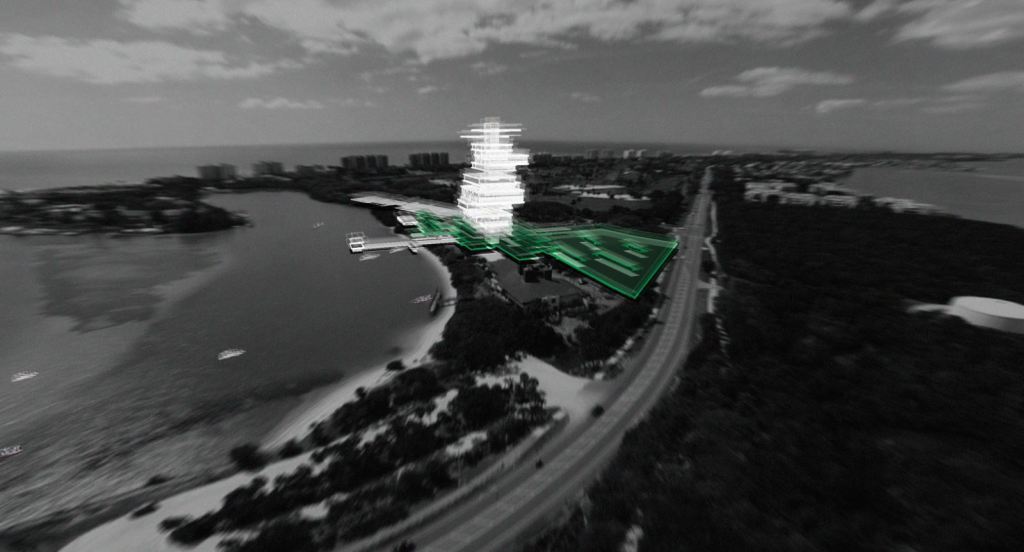
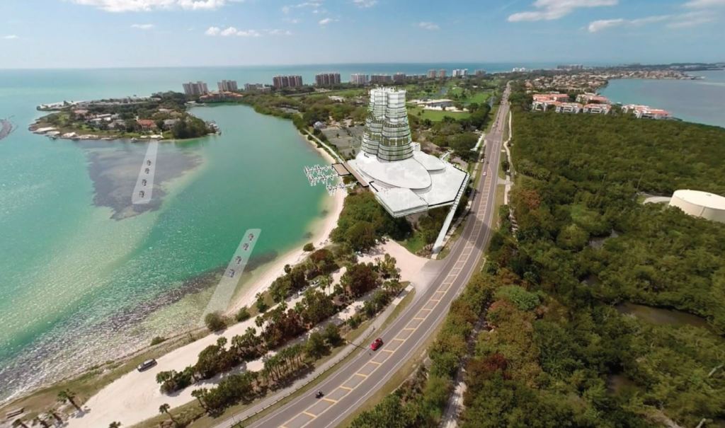
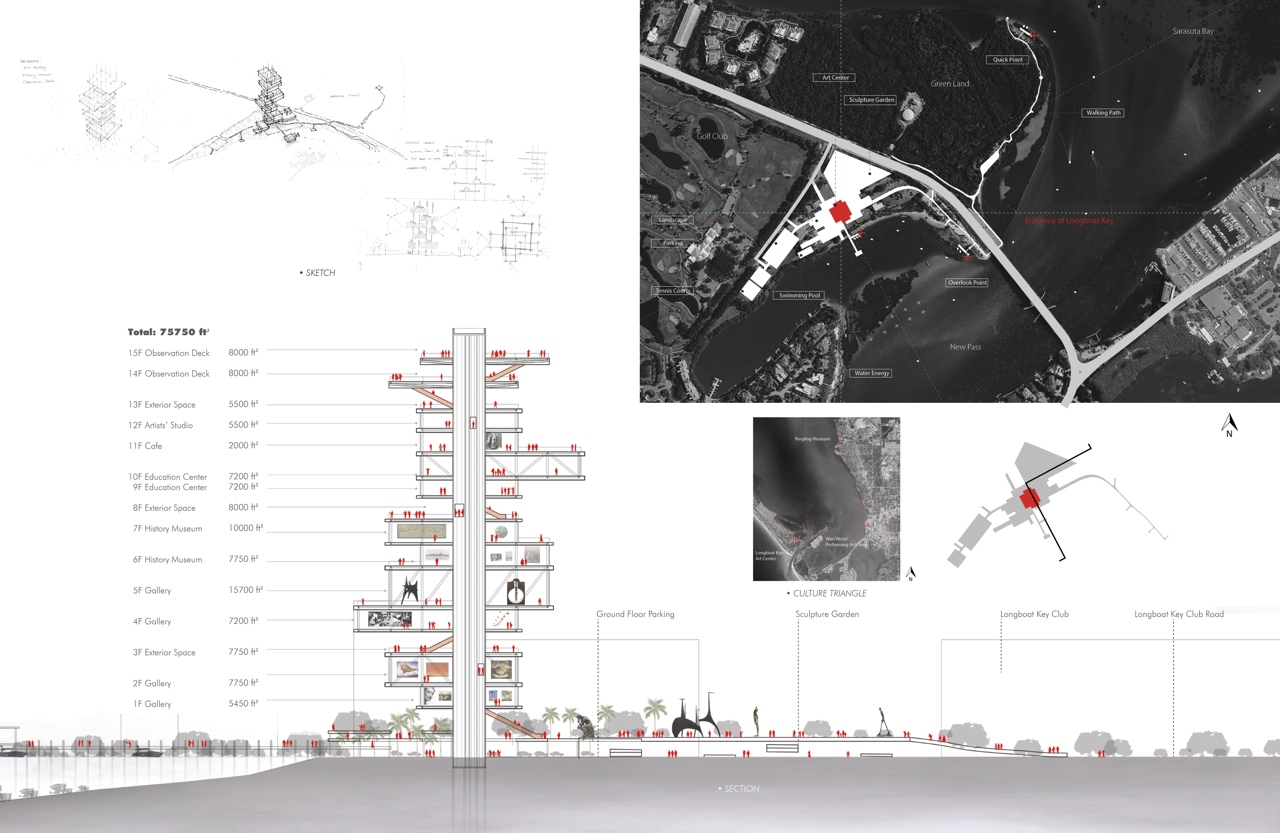
LokeMoma – Xuancheng Chu
Longboat Key Art Center Development
Aquaponica – Jessica Phillips
Aquarium + Hydroponics – New Destination Diversity
LokeMoma – Xuancheng Chu
LokeMoma will contain multiple level observation decks as a general attraction to the visitors and an art experience like no place else in the world. This project identified the possible links of Longboat Key to art facilities that give character to Sarasota Bay, such as the Ringling Museum and Quay.
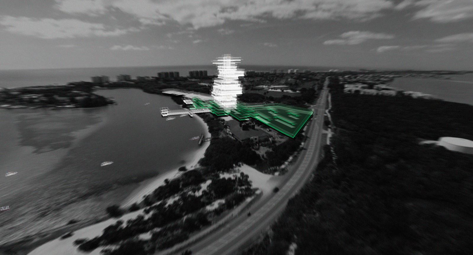
The project proposes a new Art Institution, to be an iconic structure located by the southern entrance to the Island providing a first magnitude venue for art in Longboat Key. It will be connected by water transportation to the other two, constituting the triangular Sarasota Bay Arts Circuit.
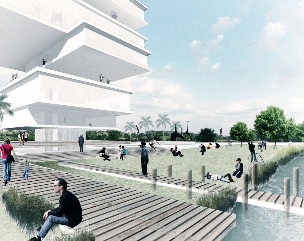

The project will provide a multiplicity of interests, from temporary exhibition galleries, a history museum, cafes, and artists’ studios, to inside venues and open-air terraces. The high-rise structure will be located over a public park where events and sculpture exhibitions will take place. It is supported by an extensive service plinth, containing parking and services, designed for economy and resilience.
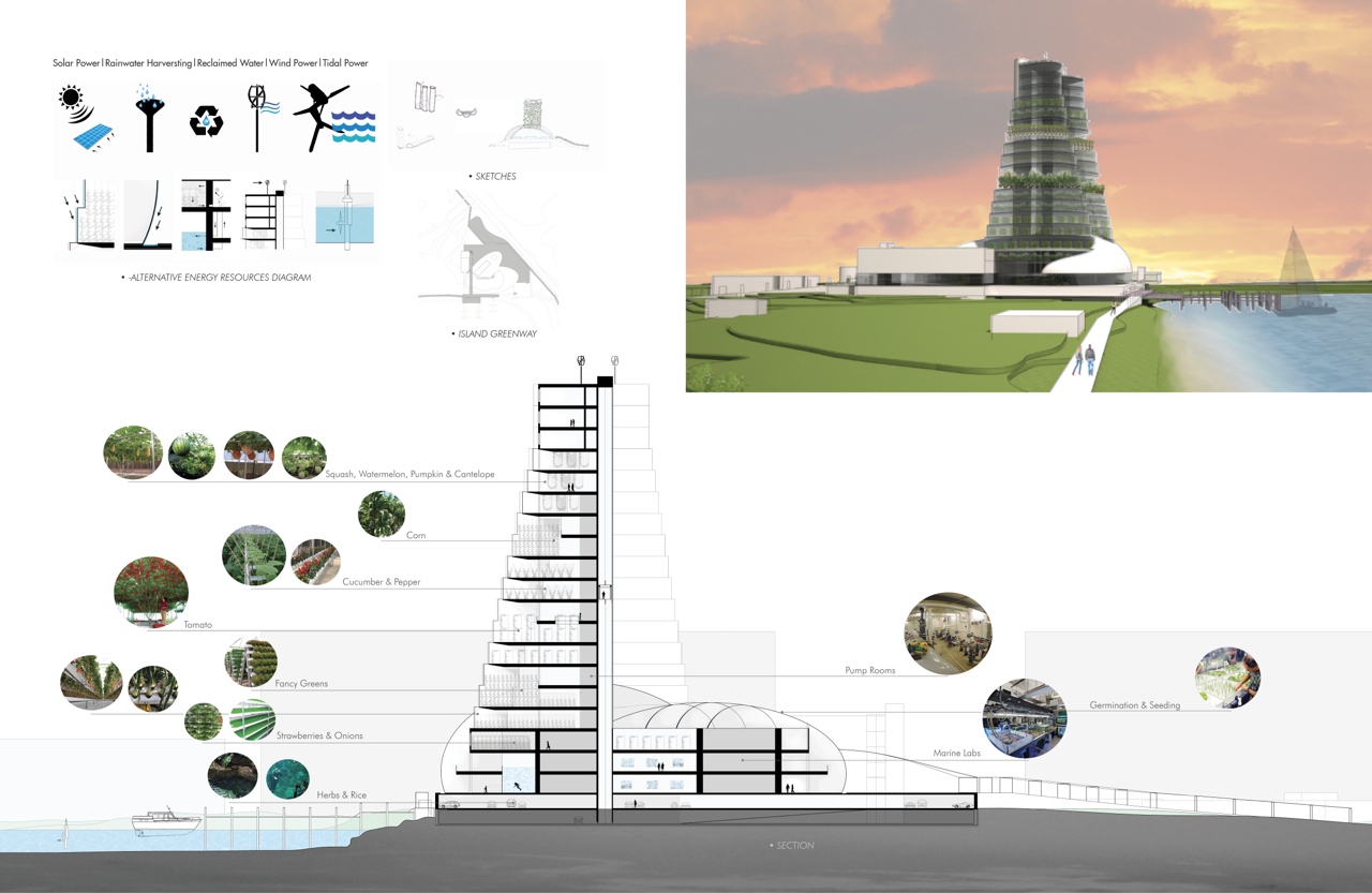
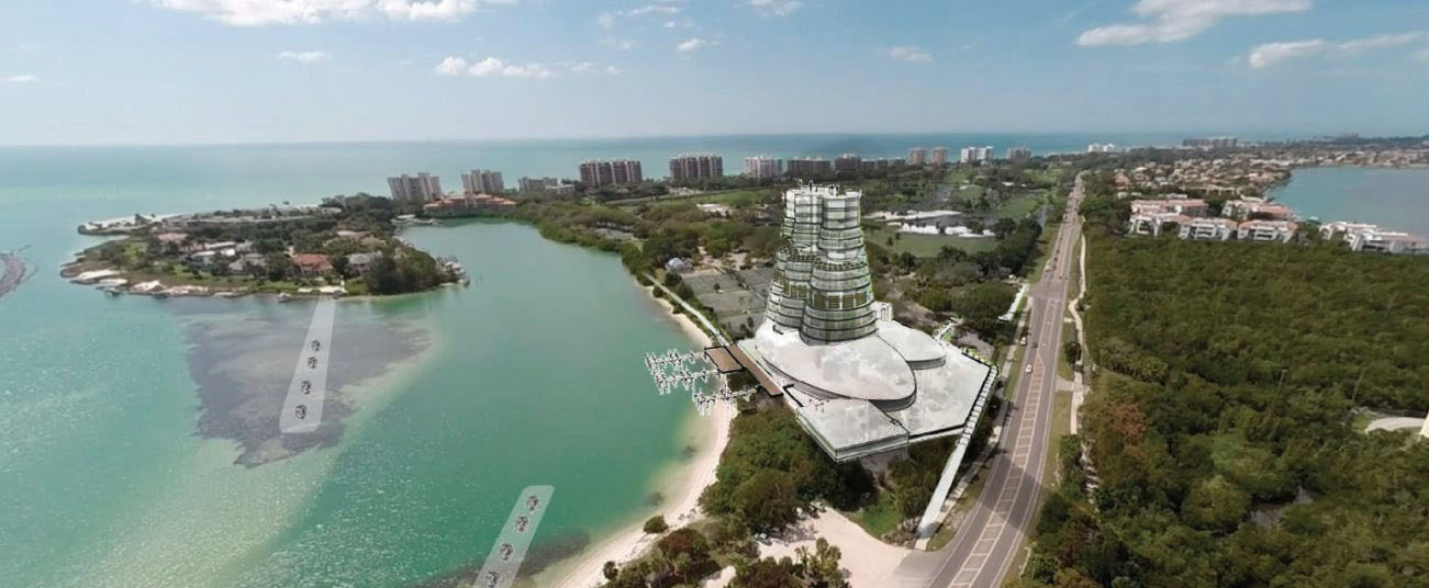
Aquaponica – Jessica Phillips
The goal is to creatively reinvigorate an underutilized commercial area that offers a unique experience at the south entrance to Longboat Key. Enjoy the expansive views of Sarasota Bay as one browses through an Aquarium and Hydroponic Farm, or enjoy lunch overlooking the water.

The project proposal is directly across from Quick Point Nature Preserve, a mangrove lagoon area that was present a hundred years ago and still serves today as a serene natural setting for shorebirds and human recreation. This location was chosen to unite the horizontal green of Nature Preserve with the new vertical hydroponic tower proposed.
The twenty-storied structure is designed to take advantage of natural light as well as tantalizing views. The south-facing elevation contains vegetation, where each level is offset from the next for optimal sunlight. Meanwhile, the high-rise tower naturally shades the aquarium.
To help fund such an endeavor, an aquarium is designed at the base of the tower, where visitors could come and enjoy a variety of beautiful freshwater fish that help feed the growing vegetation above. It provides an iconic entrance marker to the Key while developing an innovative program that sustains healthy options for the Key.